Brevard County Under Tropical Storm Advisories As Future "Imelda" Strengthens
September 28, 2025 -- 01:30am By: Joe Cantoras // TheBlakeMoiaShow.com Certified Chief Meteorologist & Tropical Weather Expert
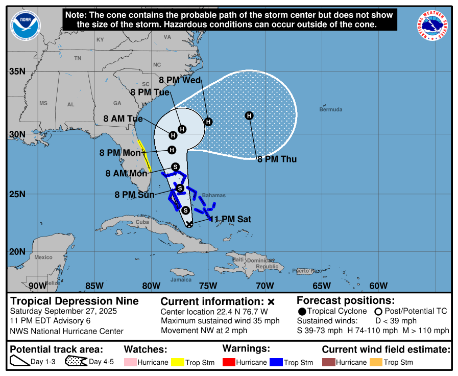
- 11pm tropical advisory for Tropical Depression 9
- TPC 9 Forecasted to become Category 1 Hurricane over the weekend
- Tropical storm warnings issued for the Bahamas; Advisories for east coast of Florida
- Better model guidance on track
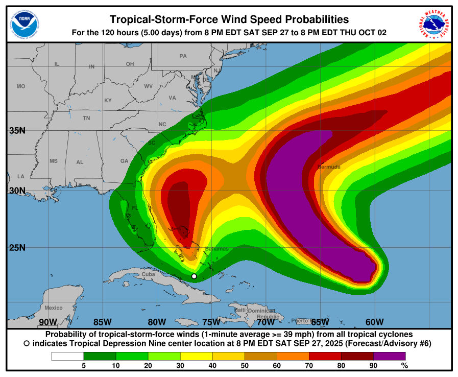
- Increased odds for tropical storm force winds in the Brevard County area and points along the east coast
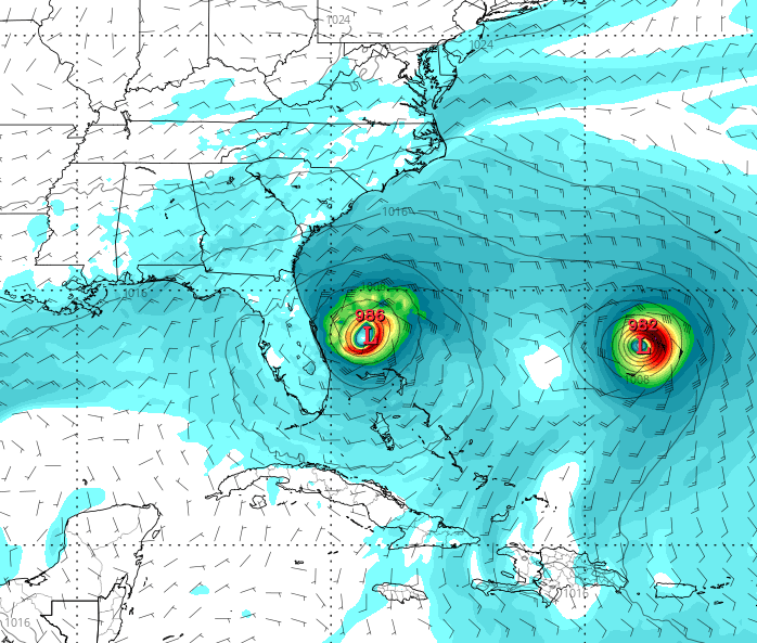
TBMS future forecast model showing a hurricane strengthening just off the Florida east coast.
- BULLETIN
- Tropical Depression Nine
- Advisory Number 6
- NWS National Hurricane Center Miami FL
- AL092025 1100 PM EDT Sat Sep 27 2025
DEPRESSION MEANDERING TO THE SOUTH OF THE CENTRAL BAHAMAS.
HEAVY RAINS EXPECTED TO CONTINUE OVER PARTS OF EASTERN CUBA AND THE BAHAMAS OVER THE NEXT DAY.
SUMMARY OF 1100 PM EDT...0300 UTC
INFORMATION -----------------------------------------------
- LOCATION...22.4N 76.7W ABOUT 220 MI...355 KM NW OF THE EASTERN TIP OF CUBA ABOUT 100 MI...160 KM SW OF THE CENTRAL BAHAMAS
- MAXIMUM SUSTAINED WINDS...35 MPH...55 KM/H
- PRESENT MOVEMENT...NW OR 310 DEGREES AT 2 MPH...4 KM/H
- MINIMUM CENTRAL PRESSURE...1004 MB...29.65 INCHES
WATCHES AND WARNINGS --------------------
SUMMARY OF WATCHES AND WARNINGS IN EFFECT:
A Tropical Storm Warning is in effect for...
- * Central Bahamas, including Cat Island, the Exumas, Long Island, Rum Cay, and San Salvador * Portions of the northwestern Bahamas, including Eleuthera, New Providence, the Abacos, Berry Islands, Andros island, and Grand Bahama Island
A Tropical Storm Watch is in effect for...
- * East coast of Florida from the Palm Beach/Martin County Line to the Flagler/Volusia County Line
A Tropical Storm Warning means that tropical storm conditions are expected somewhere within the warning area, within 36 hours.
A Tropical Storm Watch means that tropical storm conditions are possible within the watch area, generally within 48 hours.
Interests elsewhere in the Bahamas and along the southeast coast of the United States from Florida to North Carolina should monitor the progress of this system. Additional watches or warnings could be required on Sunday.
For storm information specific to your area in the United States, including possible inland watches and warnings, please monitor products issued by your local National Weather Service forecast office. For storm information specific to your area outside of the United States, please monitor products issued by your national meteorological service.
- DISCUSSION AND OUTLOOK ----------------------
At 1100 PM EDT (0300 UTC), the center of Tropical Depression Nine was located by NOAA reconnaissance aircraft near latitude 22.4 North, longitude 76.7 West. The depression has been meandering with a very slow motion toward the northwest near 2 mph (4 km/h). A faster motion to the north-northwestward motion is expected to begin on Sunday and continue through Monday.
On the forecast track, the center of the system is expected to move across the central and northwestern Bahamas on Sunday and Sunday night and approach the southeast U.S. coast early next week.
Maximum sustained winds remain near 35 mph (55 km/h) with higher gusts. Strengthening is expected during the next few days, and the system is forecast to become a tropical storm overnight or early Sunday and a hurricane by late Monday or Tuesday. The estimated minimum central pressure measured by aircraft dropsonde data is 1004 mb (29.65 inches).
- HAZARDS AFFECTING LAND ----------------------
WIND:
- Tropical storm conditions are expected in the central Bahamas beginning tonight or early Sunday and in the northwestern Bahamas on Sunday. Tropical storm conditions are possible in the watch area along the east coast of Florida on Monday.
RAINFALL:
- Tropical Depression Nine is expected to produce additional rainfall of 4 to 8 across eastern Cuba and the Bahamas.
- This rainfall will likely produce flash and urban flooding.
- Mudslides are also possible in areas of higher terrain across eastern Cuba. The system is also expected to bring a threat of heavy rainfall from the east coast of Florida northward into the eastern Carolinas.
- Rainfall amounts of 3 to 6 inches are possible, with localized totals of 10 inches across portions of the coastal Carolinas. This rainfall could result in flash, urban, and river flooding. Changes in the forecast track could result in adjustments to these rainfall totals.
- For a complete depiction of forecast rainfall and flash flooding associated with the system, please see the National Weather Service Storm Total Rainfall Graphic, available at hurricanes.gov/graphics_at4.shtml?rainqpf.
STORM SURGE:
- A storm surge will raise water levels by as much as 1 to 3 feet above ground level along the immediate coast in areas of onshore winds in the northwestern Bahamas. Near the coast, the surge will be accompanied by large waves.
SURF:
- Swells generated by this system and Hurricane Humberto will affect portions of the Bahamas this weekend, and spread to portions of the southeast U.S. coast early next week.
- These swells are likely to cause life-threatening surf and rip current conditions. Please consult products from your local weather office.
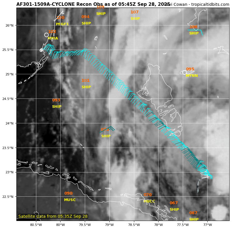
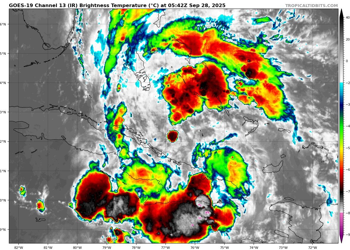
Latest Satellite Image Loop Of PTC Nine
- Tropical Depression Nine Discussion Number 6
- NWS National Hurricane Center Miami FL
- AL092025 1100 PM EDT Sat Sep 27 2025
The depression this evening remains fairly disorganized, with convection mainly oriented in a north-south fashion with only a hint of banding on the northern side. A NOAA-P3 aircraft that has been flying through the system only found a peak 700 mb flight level wind of 34 kt about 60 n mi away from the center.
Tail Doppler Radar (TDR) analysis from the aircraft also shows the center is quite broad at the 1 km level with the mid-level center tilted to the south with height.
Based on the plane data, the initial intensity remains 30 kt this advisory, which is a little under the various satellite-based estimates, but close to a recently received scatterometer pass which had a peak wind of 31 kt. Aircraft fixes both at 700 mb and from the TDR analysis shows the cyclone is meandering right now, with a best guess at a motion of 310/2 kt. Over the next couple of days, the system should turn north-northwestward with a somewhat faster forward motion, moving within the flow between an upper trough over the southeast U.S. and a subtropical ridge over the Atlantic.
This forecast brings the depression over the central and northwestern Bahamas through early Monday, then toward the southeast U.S. coast by Tuesday. It is notable to point out the system has been moving slower than anticipated over the last 12-24 hours, and this could have significant implications on its ultimate track.
Even in the first 48 hours of the track, there is quite a bit of spread in the north-south direction in both the deterministic and ensemble model guidance. Faster tracks appear to interact more with the upper-level trough to the west, resulting in a track closer to the Carolina coastline, while slower tracks largely miss a direct interaction with this feature, and turn sharply east faster as Hurricane Humberto approaches from the east, eroding the mid-level ridging steering TD9 northward.
Because it has been moving slower than expected, its becoming more likely its ultimate track will fall in the slower and sharper east camp. In response, the overall track guidance this cycle shifted slower and further east, and the NHC track forecast was shifted in that direction.
The latest track roughly splits the difference between the ECMWF and GFS tracks, and lies quite close to the HCCA consensus aid, but still not as far south and east as the Google DeepMind ensemble mean (GDMI). The depression is not showing signs of intensification yet, with a broad diffuse structure on aircraft observations persisting.
However, the intensity guidance is insistent that deep central convection will soon form near the center, helping to tighten up the surface wind field. While the cyclone will have some southerly shear to deal with, it does not appear to be prohibitively strong, only 15-20 kt for the next 48 hours in both the GFS and ECMWF-based SHIPS guidance.
That, combined with warm 29-30 C sea-surface temperatures should promote steady intensification once a central core develops, and the NHC intensity forecast was nudged up a little higher showing a 70 kt peak in 48 hours. After this period is where the intensity forecast gets tricky.
The large spread in north-south tracks also has a significant impact on the amount of shear the system will face in the 48-96 hour time-frame. Solutions that are further south have less shear to contend with and are generally stronger. For now, the latest intensity forecast will cap the peak intensity at 70 kt through the end of the forecast, close to the HCCA intensity guidance, but this could be conservative if the track shifts further south and east.
The system could also interact with a baroclinic zone towards the end of the forecast, but because the forecast track remains over warm waters at day 5, extratropical transition won't be shown quite yet.
Even if this further offshore track pans out, the wind field is expected to expand quite a bit, and given the expected storm structure, a risk of significant heavy rainfall, storm surge, and wind impacts is still possible for the southeast U.S. coast even if the storm center remains offshore.
KEY MESSAGES:
- 1. The depression is expected to strengthen and bring tropical storm conditions to portions of the central and northwestern Bahamas through Sunday night. Tropical storm conditions are also possible along portions of the east coast of central Florida beginning Monday, where a Tropical Storm Watch is in effect.
- 2. Rainfall will continue to impact eastern Cuba and the Bahamas through the weekend, which will likely produce flash and urban flooding. Mudslides are possible in the higher terrain.
- 3. There is a significant threat of heavy rainfall early next week from portions of the east coast of Florida northward into the Carolinas, which could cause flash, urban, and river flooding.
- 4. The depression is expected to be at or near hurricane intensity when it is closest to the southeast U.S. coast early next week, where there is a risk of storm surge and wind impacts. Although it is too soon to specify the exact location and magnitude of impacts, residents should closely monitor the latest forecast updates and ensure that they have their hurricane plan in place.
MORE WEATHER: THE BLAKE MOIA SHOW 2025 HURRICANE PREDICTION CENTER