Hurricane Debby Makes Landfall in Florida - BIBLICAL Flooding Expected in GA, SC
5pm - Aug 05, 2024 -- 3:03am
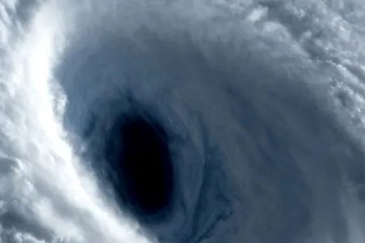
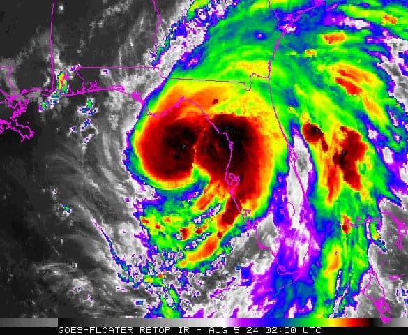
The National Hurricane Center Hurricane Debby is now a Category 1 Hurricane with Winds at 75 MPH. Hurricane Debby is expected to make landfall soon in the Big Bend region of Florida.
After it passes through the upper region of Florida, Hurricane Debby is expected to stall out over or near the Atlantic waters near Georgia and South Carolina. Forecasters believe historic biblical flooding is to arrive in this region this week.
This storm is expected to linger for a few days, if not, all week, forecasters say. Power outages have been reported in Sumter, Pinellas Counties in Florida. There are currently 2,000 people without power as of this update.
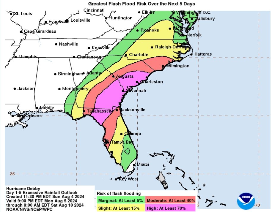
FLORIDA, GEORGIA AND SOUTH CAROLINA UNDER STATE OF EMERGENCY IN PREPERATION FOR HURRICANE DEBBY
Officials says to take measures now to protect your home, stock up on essential supplies. The Blake Moia Show recommends testing your generators and get them serviced now to ensure they are in working proper order. Remember to never run generators indoors.
States of Emergency has been declared for Georgia and South Carolina as well.
Torrential monsoon downpours and flooding is widely expected throughout the state of Florida, into Georgia and South Carolina Monday and throughout the rest of the week, forecasters say.
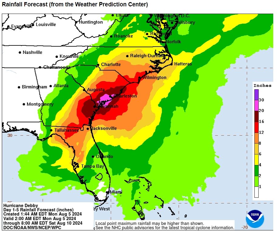
20''-30'' of inches of torrential rainfall with hurricane force winds and gusts is expected in Savannah, Ga and Charleston, Sc.
Residences are seen packing up sandbags and preparing for a major widespread flooding disaster.
Evacuations Underway for Costal Cities
Public safety officials and experts recommend bringing the following items when evacuating:
- Water: one gallon per person, per day (3-day supply for evacuation)
- Food: non-perishable, 3-day supply for evacuation and other special food items
- Bedding/sleeping items
- Prescription and emergency medications for all family members
- Medical supplies (hearing aids with extra batteries, glasses, contact lenses, syringes, cane)
- Copies of personal documents (medication list and pertinent medical information, proof of address, deed/lease to home, passports, birth certificates, insurance policies)
- Sanitation and personal hygiene products
- Personal care and other comfort items
- Photo ID, cash
- Extra clothing
- Special items for infants, like diapers, baby food, medication
- Family pets: kennel, food and special medication
- Power cords for portable electronics
President Biden Approves Emergency Declaration
President Joe Biden has approved a Florida emergency declaration for Tropical Storm Debby, approving "federal assistance and reimbursement for mass care, including evacuation and shelter support."
"The President’s action authorizes the Department of Homeland Security, Federal Emergency Management Agency (FEMA), to coordinate all disaster relief efforts which have the purpose of alleviating the hardship and suffering caused by the emergency on the local population, and to provide appropriate assistance for required emergency measures," reads a White House press release.
South Carolina Govenor Declares State of Emergency
Gov. McMaster of South Carolina declared a State of Emergency for his state of South Carolina ahead of the expected biblical flooding.
"Team South Carolina is closely monitoring Tropical Storm Debby and has begun preparing for its potential impact on our state," said Governor Henry McMaster. "With a potentially significant rainfall event forecast for the next few days, it is critical that residents in potentially affected areas start making preparations and plans today—in case it is necessary to take quick action," the press statement says.
The Govenor authorized the deployment of the National Guard Statesmen to assist with heavy equipment and high-water rescues.
"South Carolina residents and visitors in potentially vulnerable areas should review their plans and consider actions they would need to take if the storm threatens the state. Everyone should monitor the storm via local news media and follow updates from the National Hurricane Center, especially people in low-lying areas along the South Carolina coast."
Govenor of Georgia Declares State of Emergency
The Govenor of Georgia, Brian Kemp, also declared a state of emergency in anticipation for the flooding hurricane.
In a statement released by the Georgia Emergency Management and Homeland Security Agency, "our agency braces for potential impacts from Tropical Storm Debby, we’d like to encourage all residents and visitors to pay attention to trusted news sources, weather alerts and local officials,” said GEMA/HS Director Chris Stallings.
Officials urge people not to walk through flood waters.
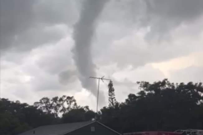
In case of flooding, do not drive or walk through standing water or drive around barricades. Stay away from downed power lines to avoid the risk of electric shock or electrocution. If a tornado warning is issued, storm cellars or basements provide the best protection. If an underground shelter is not available, go to a small, windowless interior room or hallway on the lowest floor possible.
What FEMA Says
The Federal Emergency Management Agency says that the warehouses are all stocked with supplies and are monitoring the storm.
“We are actively monitoring the potential impacts of Tropical Storm Debby, and our FEMA regional team is on the ground and integrated with our state colleagues at the Florida emergency operation center. This slow-moving storm could bring historic flooding, and I urge residents and visitors in the storm's path across Florida, Georgia and South Carolina to listen to their local officials and finalize preparation plans today. The time spent today making a plan can help protect you and your family from the impacts the storm may bring in the coming days," FEMA Administrator Deanne Criswell said.
"A FEMA distribution center located in Atlanta is fully stocked and ready to mobilize commodities if requested to support state's response efforts. A FEMA Incident Management Assistance Team is at the Florida emergency operations center in Tallahassee, and FEMA Liaisons are expected to arrive at 11 county emergency management offices today. Additionally, FEMA is pre-staging Urban Search and Rescue teams to assist the affected states."
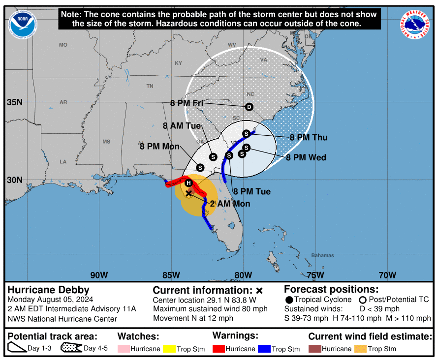
BULLETIN Hurricane Debby Intermediate Advisory Number 11A
NWS National Hurricane Center Miami FLAL042024 200 AM EDT Mon Aug 05 2024
DEBBY STRENGTHENING AS IT NEARS LANDFALL IN THE FLORIDA BIG BEND... ...EXPECTED TO BRING LIFE-THREATENING STORM SURGE IN PORTIONS OF FLORIDA AND MAJOR FLOODING IN THE SOUTHEASTERN UNITED STATES...
INFORMATION ----------------------------------------------
LOCATION...29.1N 83.8W ABOUT 40 MI...70 KM W OF CEDAR KEY FLORIDA ABOUT 95 MI...150 KM SSE OF TALLAHASSEE FLORIDA MAXIMUM SUSTAINED WINDS...80 MPH...130 KM/H PRESENT MOVEMENT...N OR 010 DEGREES AT 12 MPH...19 KM/H MINIMUM CENTRAL PRESSURE...981 MB...28.97 INCHES
HAZARDS TO EFFECT LAND
WIND: Hurricane conditions are expected in the hurricane warning area later this morning. Tropical storm conditions will continue to spread northward over the tropical storm warning area along the Florida Gulf coast through the morning, and begin along portions of the tropical storm warning area along the Atlantic coast by this evening. Tropical storm conditions are expected along the coast of South Carolina within the tropical storm warning area by late tonight.
STORM SURGE: The combination of storm surge and tide will cause normally dry areas near the coast to be flooded by rising waters moving inland from the shoreline. The water could reach the following heights above ground somewhere in the indicated areas if the peak surge occurs at the time of high tide...
- Yankeetown, FL to Ochlockonee River, FL...6-10 ft
- Chassahowitzka, FL to Yankeetown, FL...4-6 ft
- Ochlockonee River, FL to Indian Pass, FL...4-6 ft
- Middle of Longboat Key, FL to Chassahowitzka, FL...3-5 ft
- Tampa Bay...3-5 ft
- Mouth of the St. Mary's River to South Santee River, SC...2-4 ft
- Middle of Longboat Key, FL to Englewood, FL...2-4 ft
RAINFALL: Hurricane Debby is expected to produce rainfall totals of 6 to 12 inches, with maximum amounts of 18 inches, across portions of central and northern Florida and southeastern North Carolina through Friday morning. This rainfall will likely result in areas of considerable flash and urban flooding, with significant river flooding expected. Across portions of southeast Georgia and South Carolina, 10 to 20 inches of rainfall, with local amounts to 30 inches, are expected through Friday morning.
This potentially historic rainfall will likely result in areas of catastrophic flooding.
TORNADOES: A few tornadoes are possible over central and northern Florida and southern Georgia today. The threat will spread northeastward into coastal Georgia and parts of South Carolina later today.
SURF: Swells generated by Debby are expected to affect much of the Gulf coast of Florida through tonight. Swells will begin to affect the Southeast U.S. coast later today and continue through the middle of the week. These conditions are likely to cause life-threatening surf and rip current conditions. Please consult products from your local weather office.
NEXT ADVISORY ------------- Next complete advisory at 500 AM EDT. $$ Forecaster Cangialosi
KEY MESSAGES
1. Potentially historic heavy rainfall across southeast Georgia and South Carolina through Friday morning will likely result in areas of catastrophic flooding. Heavy rainfall will likely result in considerable flooding impacts from portions of central and northern Florida through the Coastal Plain of the Carolinas through Friday.
2. There is a danger of life-threatening storm surge along portions of the Gulf Coast of Florida, with 6 to 10 feet of inundation above ground level expected somewhere between Ochlockonee River to Yankeetown late tonight and Monday morning. Residents in the Storm Surge Warning area should follow any advice given by local officials.
3. Hurricane conditions are expected Monday along portions of the Florida Big Bend region where a Hurricane Warning is in effect, with tropical storm conditions beginning this evening. Tropical storm conditions are expected through Monday farther south within the Tropical Storm Warning area along Florida's west coast, including the Tampa Bay area.
4. Dangerous storm surge and wind impacts are expected along portions of the southeast U.S. coast from northeastern Florida to North Carolina through the middle of the week, and storm surge warnings and tropical storm watches and warnings have been issued for portions of these areas.
WATCHES AND WARNINGS
SUMMARY OF WATCHES AND WARNINGS IN EFFECT:
A Storm Surge Warning is in effect for...
* Florida coast from the middle of Longboat Key northward to Indian Pass including Tampa Bay
* Georgia and South Carolina coast from the Mouth of the St. Mary's River to South Santee River South Carolina
A Storm Surge Watch is in effect for...
* Florida coast from Englewood northward to the middle of Longboat Key, including Charlotte Harbor
A Hurricane Warning is in effect for...
* Florida coast from the Yankeetown to Indian Pass
A Tropical Storm Warning is in effect for...
* Florida coast south of Yankeetown to Boca Grande
* Florida coast from west of Indian Pass to Mexico Beach
* St. Augustine to South Santee River South Carolina
This is a life-threatening situation. Persons located within these areas should take all necessary actions to protect life and property from rising water and the potential for other dangerous conditions. Promptly follow evacuation and other instructions from local officials.
Interests elsewhere along the southeastern coast of the United States should monitor the progress of this system. Additional watches and warnings will likely be required later today.
No Price Gouging
Florida's attorney general activates price gouging hotline ahead of storm. A press release from Moody's office said, "price gouging laws are now in effect for the counties covered by the state of emergency: Alachua, Baker, Bay, Bradford, Calhoun, Charlotte, Citrus, Clay, Collier, Columbia, Dixie, Duval, Escambia, Flagler, Franklin, Gadsden, Gilchrist, Gulf, Hamilton, Hernando, Hillsborough, Holmes, Jackson, Jefferson, Lafayette, Lake, Lee, Leon, Levy, Liberty, Madison, Manatee, Marion, Monroe, Nassau, Okaloosa, Orange, Osceola, Pasco, Pinellas, Polk, Putnam, Santa Rosa, Sarasota, Seminole, St. Johns, Sumter, Suwannee, Taylor, Union, Volusia, Wakulla, Walton and Washington counties."
Anyone who suspects price gouging can report it to the Florida Attorney General’s Office by visiting MyFloridaLegal.com or calling 1(866) 9NO-SCAM.
Florida’s price gouging law applies to items and services essential to getting ready for, or recovering from, a storm within the areas of a declared state of emergency, the press release explained. That may include generators, food, gasoline, hotel rooms, ice, lumber and water.
"Violators of the price gouging statute are subject to civil penalties of $1,000 per violation and up to a total of $25,000 for multiple violations committed in a single 24-hour period," the release said.
“Invest 97L is expected to bring heavy rain and powerful winds to much of the state," Moody said in a statement. "To help Floridians prepare for this event, we are activating the price gouging hotline to accept reports of extreme price increases on essential commodities. As the system approaches, I’m urging Floridians to finalize their storm preparations, monitor weather reports and follow the guidance of local authorities.”