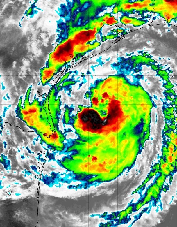
Update: Tropical Storm Beryl Nearing Landfall in Texas
By: The Underground Meteorologist - For The Blake Moia Show -- 11pm, July 03, 2024
The Atlantic 2024 Hurricane Season is starting out with a bang. The first hurricane of the season was a category 5 monster and has significantly weakened after passing through Cancun and Cozumel. It's next stop is now Texas.
According to Levi Cowan, from TropicalTidbits.com, Hurricane Beryl has met or exceeded forecast expectations.
Blake Moia has noted that every single model run of this storm has been wrong so far. "The starting points of the model runs has been farther south than the eye of the hurricane really is."
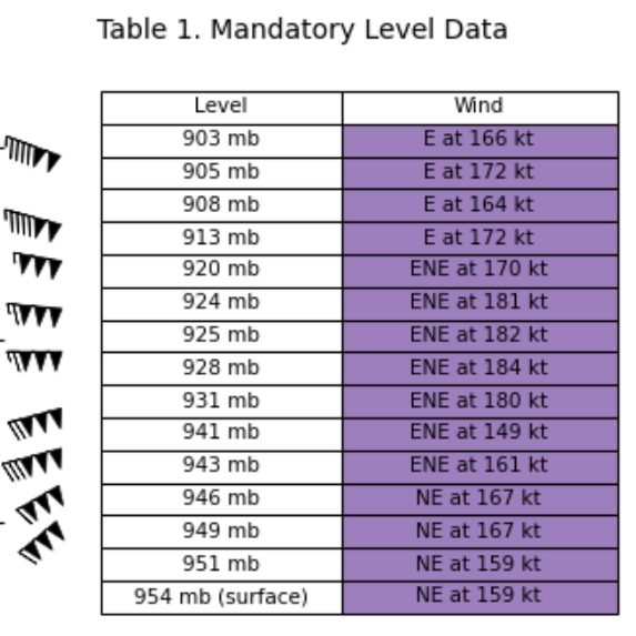
The Hurricane Hunters Saw 184kt Winds on 07/02 During Peak of Storm
.
VIDEO: Hurricane Beryl Makes Landfall as a Strong Category 4 Hurricane on the Island of Carriacou
The official Hurricane Center Discussion:
WHAT THE EXPERTS ARE SAYING
BERYL FORECAST TO BRING DANGEROUS STORM SURGE, FLASH FLOODING AND STRONG WINDS TO TEXAS OVERNIGHT... SUMMARY OF 400 PM CDT...2100 UTC...
INFORMATION ----------------------------------------------
LOCATION...26.8N 95.5W ABOUT 130 MI...205 KM SSE OF MATAGORDA TEXAS ABOUT 135 MI...220 KM ESE OF CORPUS CHRISTI TEXAS MAXIMUM SUSTAINED WINDS...65 MPH...100 KM/H PRESENT MOVEMENT...NNW OR 335 DEGREES AT 12 MPH...19 KM/H MINIMUM CENTRAL PRESSURE...988 MB...29.18 INCHES
WATCHES AND WARNINGS --------------------
CHANGES WITH THIS ADVISORY:
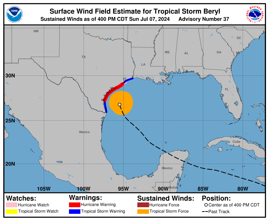
The government of Mexico has discontinued the Tropical Storm Warning for northeastern coast of mainland Mexico from Barra el Mezquital to the mouth of the Rio Grande River. The Storm Surge Watch from North of Baffin Bay, Texas to North Entrance of the Padre Island National Seashore has been discontinued.
SUMMARY OF WATCHES AND WARNINGS IN EFFECT:
A Storm Surge Warning is in effect for...
* North Entrance of the Padre Island National Seashore to Sabine Pass, including Corpus Christi Bay, Matagorda Bay, and Galveston Bay
A Hurricane Warning is in effect for...
* The Texas coast from Baffin Bay northward to San Luis Pass A Hurricane Watch is in effect for...
* The Texas coast north of San Luis Pass to Galveston Island A Tropical Storm Warning is in effect for...
* The Texas coast south of Baffin Bay to the mouth of the Rio Grande
* The Texas coast north of San Luis Pass to Sabine Pass A Hurricane Warning means that hurricane conditions are expected somewhere within the warning area.
A Hurricane Watch means that hurricane conditions are possible within the watch area.
A Tropical Storm Warning means that tropical storm conditions are expected within the warning area.
A Storm Surge Warning means there is a danger of life-threatening inundation, from rising water moving inland from the coastline, during the next 36 hours in the indicated locations. For a depiction of areas at risk, please see the National Weather Service Storm Surge Watch/Warning Graphic, available at hurricanes.gov.
This is a life-threatening situation.
Persons located within these areas should take all necessary actions to protect life and property from rising water and the potential for other dangerous conditions. Promptly follow evacuation and other instructions from local officials. For storm information specific to your area, including possible inland watches and warnings, please monitor products issued by your local National Weather Service forecast office.
DISCUSSION AND OUTLOOK ----------------------
At 400 PM CDT (2100 UTC), the center of Tropical Storm Beryl was located near latitude 26.8 North, longitude 95.5 West. Beryl is moving toward the north-northwest near 12 mph (19 km/h). This general motion is expected to continue through tonight, with a turn toward the north forecast on Monday.
On the forecast track, the center of Beryl is expected to make landfall on the middle Texas coast early Monday. Beryl is forecast to turn northeastward and move farther inland over eastern Texas and Arkansas late Monday and Tuesday.
Maximum sustained winds remain near 65 mph (100 km/h) with higher gusts. Strengthening is expected, and Beryl is forecast to become a hurricane again tonight. Additional strengthening is expected before Beryl reaches the Texas coast early Monday. Tropical-storm-force winds extend outward up to 115 miles (185 km) from the center.
The estimated minimum central pressure is 988 mb (29.18 inches) based on Air Force Reserve dropsonde data.
HAZARDS AFFECTING LAND ----------------------
Key messages for Beryl can be found in the Tropical Cyclone Discussion under AWIPS header MIATCDAT2, WMO header WTNT42 KNHC, and on the NHC website at hurricanes.gov/text/MIATCDAT2.shtml.
WIND: Hurricane conditions are expected in the hurricane warning area by early Monday. Winds are first expected to reach tropical storm strength by late today, making outdoor preparations difficult or dangerous.
Hurricane conditions are possible in the hurricane watch areas by early Monday, with tropical storm conditions beginning by tonight. Tropical storm conditions are expected in the tropical storm warning areas in south Texas starting within the next few hours.
Tropical storm conditions are expected in the tropical storm warning area along the upper Texas coast early Monday.
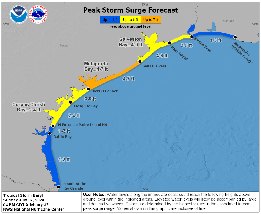
STORM SURGE: The combination of storm surge and tide will cause normally dry areas near the coast to be flooded by rising waters moving inland from the shoreline.
The water could reach the following heights above ground somewhere in the indicated areas if the peak surge occurs at the time of high tide...
Port O'Connor, TX to San Luis Pass, TX...4-7 ft
Matagorda Bay...4-7 ft
San Luis Pass, TX to High Island, TX...4-6 ft
Galveston Bay...4-6 ft
Mesquite Bay, TX to Port O'Connor, TX...3-5 ft
High Island, TX to Sabine Pass, TX...3-5 ft
The deepest water will occur along the immediate coast near and to the right of the center, where the surge will be accompanied by large and destructive waves.
Surge-related flooding depends on the relative timing of the surge and the tidal cycle, and can vary greatly over short distances.
For information specific to your area, please see products issued by your local National Weather Service forecast office. For a complete depiction of areas at risk of storm surge inundation, please see the National Weather Service Peak Storm Surge Graphic, available at hurricanes.gov/graphics_at2.shtml?peakSurge.
RAINFALL: Heavy rainfall of 5 to 10 inches with localized amounts of 15 inches is expected across portions of the middle and upper Texas Gulf Coast and eastern Texas through Monday night. Considerable flash and urban flooding as well as minor to isolated major river flooding is expected. For a complete depiction of forecast rainfall and flash flooding associated with Tropical Storm Beryl, please see the National Weather Service Storm Total Rainfall Graphic, available at hurricanes.gov/graphics_at2.shtml?rainqpf and the Flash Flood Risk graphic at hurricanes.gov/graphics_at2.shtml?ero
TORNADOES: A few tornadoes could occur along the middle and upper Texas Coast through tonight, and across eastern Texas into Louisiana and Arkansas on Monday.
SURF: Swells generated by Beryl are expected to affect eastern Mexico and much of the Gulf Coast of the U.S. during the next day or two.
These swells are expected to cause life-threatening surf and rip current conditions. Please consult products from your local weather office.
NEXT ADVISORY -------------
Next intermediate advisory at 700 PM CDT. Next complete advisory at 1000 PM CDT. $$ Forecaster Blake
The National Hurricane Center issues watches and warnings for the islands.
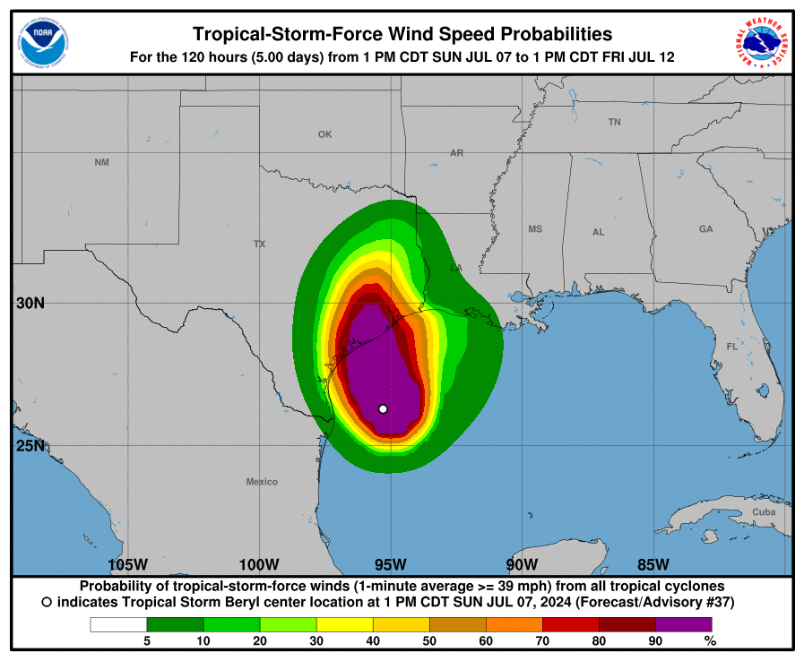
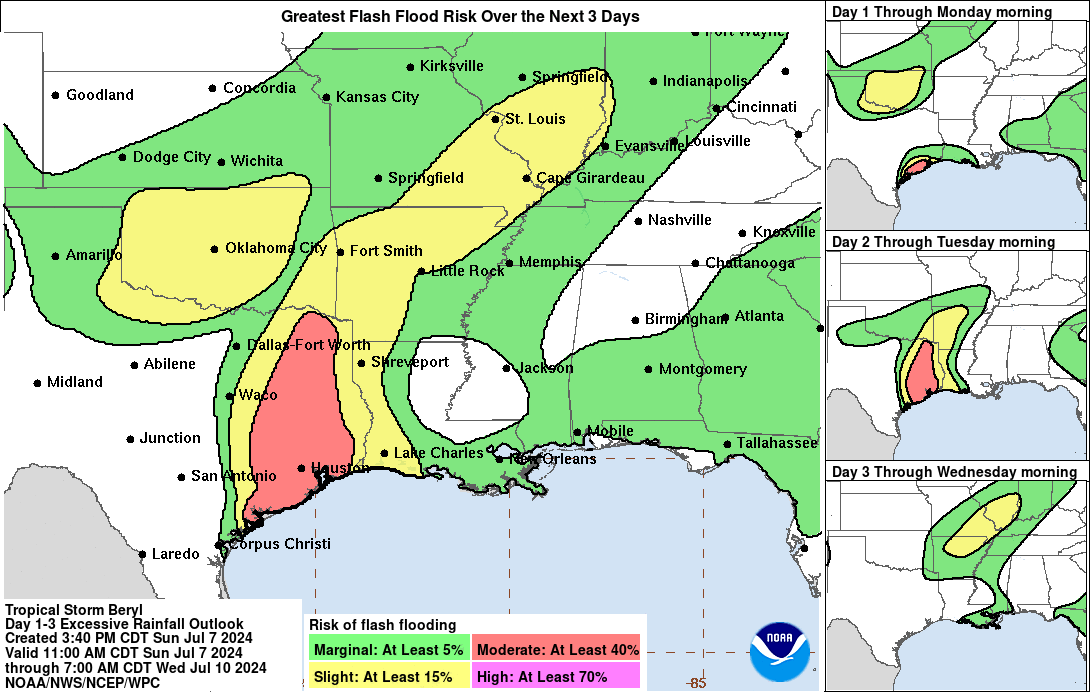



IMAGES: Hurricane Hunters Inside Beryl
Images Courtesy of the NHC Hurricane Hunters




WHAT THE NATIONAL HURRICANE CENTER SAYS
Satellite images indicate that Beryl continues to gradual organize with more banding features near the center, expanding outflow and strong bursts of convection rotating around the eyewall. However, dry air is still present within the inner core, keeping the intensification slow at this time, with only a broken banded eyewall structure.
While the central pressure reported by an Air Force Reserve Hurricane Hunter aircraft has fallen to 988 mb, there hasn't been much change in the winds reported, so the intensity remains 55 kt.
The intensity forecast is tricky because the environment is becoming quite favorable for significant intensification as Beryl should be moving over sea-surface temperatures near 87F tonight and light shear, plus even an enhancement of jet dynamics north of the storm.
All of the model guidance respond to these conditions by showing a large increase in deep convection near the center and higher winds. However, some less predictable factors could prevent a big increase in winds, including dry air in the inner core, a somewhat large radius of maximum winds, and slightly faster landfall timing.
Given that the regional hurricane models still show significant deepening, the official forecast continues to call for near rapid intensification through landfall.
Beryl has turned north-northwest at about 10 kt. The storm should turn northward overnight before making landfall along the middle Texas coast early on Monday before dawn.
The new forecast is very close to the previous one through landfall. After Beryl moves inland, the latest guidance turns the system northeastward late tomorrow and it becomes a post-tropical cyclone.
The long-term track is a bit faster and east of the last one, consistent with a blend of the ECMWF and GFS models.
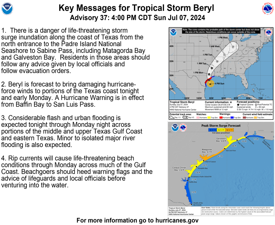
Key Messages:
1. There is a danger of life-threatening storm surge inundation along the coast of Texas from the north entrance to the Padre Island National Seashore to Sabine Pass, including Matagorda Bay and Galveston Bay. Residents in those areas should follow any advice given by local officials and follow evacuation orders.
2. Beryl is forecast to bring damaging hurricane-force winds to portions of the Texas coast tonight and early Monday. A Hurricane Warning is in effect from Baffin Bay to San Luis Pass.
3. Considerable flash and urban flooding is expected tonight through Monday night across portions of the middle and upper Texas Gulf Coast and eastern Texas. Minor to isolated major river flooding is also expected.
4. Rip currents will cause life-threatening beach conditions through Monday across much of the Gulf Coast. Beachgoers should heed warning flags and the advice of lifeguards and local officials before venturing into the water.
FORECAST POSITIONS AND MAX WINDS INIT 07/2100Z 26.8N 95.5W 55 KT 65 MPH 12H 08/0600Z 28.3N 95.9W 75 KT 85 MPH 24H 08/1800Z 30.4N 95.9W 50 KT 60 MPH...INLAND 36H 09/0600Z 32.6N 94.8W 30 KT 35 MPH...INLAND 48H 09/1800Z 34.9N 92.6W 25 KT 30 MPH...POST-TROP/INLAND 60H 10/0600Z 37.2N 89.7W 20 KT 25 MPH...POST-TROP/INLAND 72H 10/1800Z 39.7N 86.2W 20 KT 25 MPH...POST-TROP/INLAND 96H 11/1800Z 43.5N 80.0W 25 KT 30 MPH...POST-TROP/INLAND 120H 12/1800Z...DISSIPATED $$ Forecaster Blake
DRAMATIC AFTERMATH
Shocking drone video captures the total destruction that left the small island in Hurricane Beryl's wake.