Potential Tropical Cyclone #4 on its Way to Florida
5pm - Aug 02, 2024 --
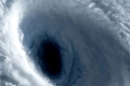
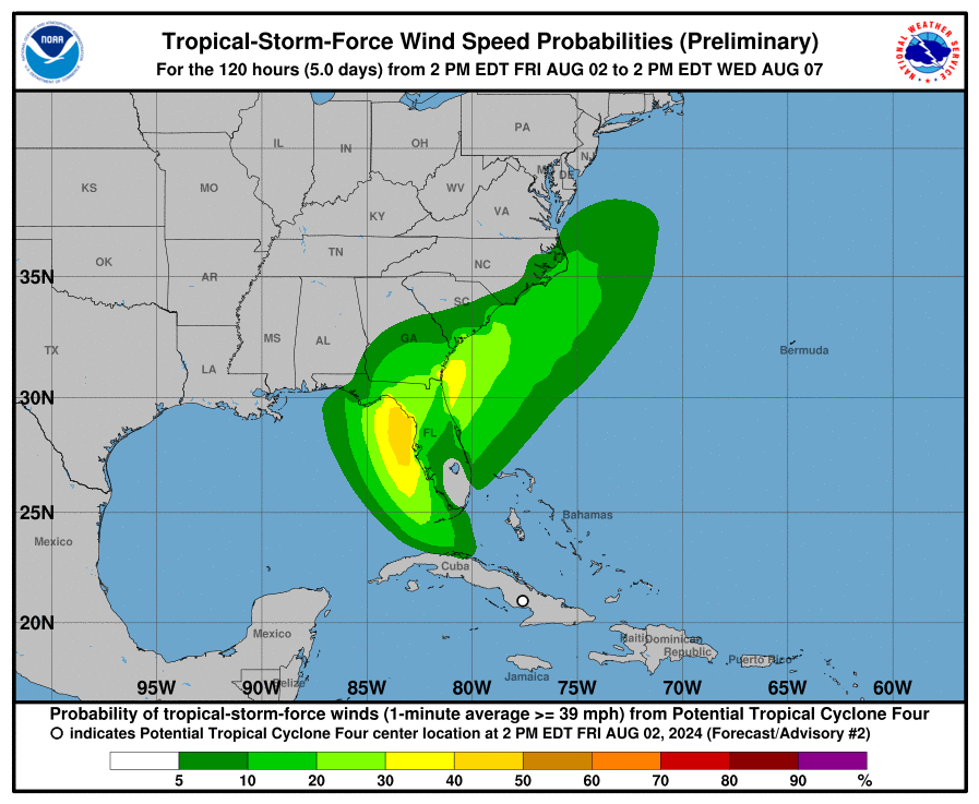
The National Hurricane Center says there is a 25% probability of Tropical Storm Force winds arriving into the Brevard County area at 8am Saturday. Forecasters say there is little dry air to impede the tropical superstorm. Ocean temperatures are at a record high for this time of the year - acting as "fuel" for this storm. Meteorologists say "Tropical Storm Debby" will be named tomorrow.
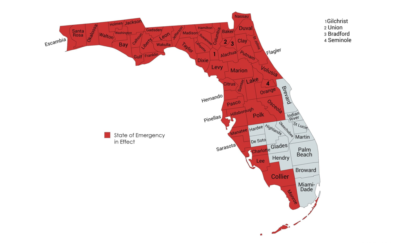
FLORIDA UNDER STATE OF EMERGENCY IN PREPERATION FOR GLOBAL WARMING SUSPERSTORM
Scientists and Meteorologists are monitoring "INVEST 97" as further development of this tropical system is expected. We expect this tropical system to eventually strengthen into a Tropical Storm or a Hurricane.
Officials says to take measures now to protect your home, stock up on essential supplies. The Blake Moia Show recommends testing your generators and get them serviced now to ensure they are in working proper order. Remember to never run generators indoors.
Torrential monsoon downpours and flooding is widely expected throughout the state of Florida on Sunday and Monday, the forecasters say.
The 54 Counties under a state of emergency: Alachua, Baker, Bay, Bradford, Calhoun, Charlotte, Citrus, Clay, Collier, Columbia, Dixie, Duval, Escambia, Flagler, Franklin, Gadsden, Gilchrist, Gulf, Hamilton, Hernando, Hillsborough, Holmes, Jackson, Jefferson, Lafayette, Lake, Lee, Leon, Levy, Liberty, Madison, Manatee, Marion, Monroe, Nassau, Okaloosa, Orange, Osceola, Pasco, Pinellas, Polk, Putnam, Santa Rosa, Sarasota, Seminole, St. Johns, Sumter, Suwannee, Taylor, Union, Volusia, Wakulla, Walton, and Washington.
Potential Tropical Cyclone Four Discussion Number 2 NWS National Hurricane Center Miami FL
AL042024 500 PM EDT Fri Aug 02 2024
Convection and vorticity associated with the tropical wave, now over central Cuba, have both increased a little this afternoon. However, the circulation is still not well-defined, and the convection is not yet well enough organized to consider the system to be a tropical depression. So, the system remains a potential tropical cyclone at this time.
A NOAA Hurricane Hunter is currently investigating the northern side of the wave, and a combination of its dropsondes and earlier scatterometer data suggest that the maximum winds remain near 25 kt. The poorly-defined center has moved more westward since the previous advisory. However the overall motion remains about 290/14 kt. A turn toward the northwest and north is expected during the next couple of days as the system moves into a break in the subtropical ridge caused by a mid-latitude trough over the Ohio Valley. This should be followed by re-curvature into the westerlies after 48-60 h.
On the forecast track, the system is expected to move into the Straits of Florida and the southeastern Gulf of Mexico on Saturday, followed by a motion near the west coast of Florida Saturday night and Sunday. After that time, the system should cross the northern Florida peninsula and move over the Atlantic near or offshore of the southeastern coast of the United States. While the track guidance generally agrees with this scenario, there are a couple of issues.
First, the GFS moves the system much faster northeastward, and by 72 h it is forecasting the center to be off of the South Carolina coast.
Meanwhile, the ECMWF and UKMET still have the center over the Gulf of Mexico.
Second, due to the track being almost parallel to both the west coast of the Florida peninsula and the southeastern U. S. coast, small changes in the track could cause large differences in potential landfalls and which land areas receive the strongest impacts. There is little change in the intensity forecast philosophy from the previous advisory.
Slow development is possible while the system is over Cuba, and the system is likely to become a tropical depression soon after it moves offshore on Saturday. The environment over the Gulf of Mexico is quite favorable for strengthening with light shear and very warm sea-surface temperatures, so subsequent steady strengthening is expected.
The two biggest uncertainties in the intensity forecast are how long the system will remain offshore of Florida and how long it will take to consolidate. The system is likely to weaken as it crosses Florida, with re-intensification likely over the Atlantic after 72 h.
Key Messages:
- 1. Heavy rainfall may result in flash and urban flooding across portions of Florida and the coastal areas of the Southeast this weekend through Wednesday morning. Isolated river flooding will also be possible.
- 2. Tropical storm conditions are expected Saturday night within the Tropical Storm Warning area in southwest Florida from East Cape Sable to Boca Grande. Tropical storm conditions are possible in the Florida Keys on Saturday and along the Florida west coast north of Boca Grande to Suwannee River Saturday night and Sunday where a Tropical Storm Watch is in effect.
- 3. There is a possibility of life-threatening inundation from storm surge along portions of the west coast of Florida from Bonita Beach to Suwannee River, including Tampa Bay and Charlotte Harbor, where a Storm Surge Watch is in effect.
- 4. Impacts from storm surge, strong winds, and heavy rains are possible elsewhere in Florida and along the southeast coast of the United States from Georgia to North Carolina through the middle of next week, and interests in those areas should continue to monitor the progress of this system.
Additional watches and warnings will likely be required later tonight and on Saturday.
FORECAST POSITIONS AND MAX WINDS INIT 02/2100Z 21.4N 78.3W 25 KT 30 MPH...
POTENTIAL TROP CYCLONE 12H 03/0600Z 22.4N 80.1W 25 KT 30 MPH...
POTENTIAL TROP CYCLONE 24H 03/1800Z 24.2N 82.2W 30 KT 35 MPH...
TROPICAL CYCLONE 36H 04/0600Z 26.1N 83.3W 35 KT 40 MPH 48H 04/1800Z 28.1N 83.3W 45 KT 50 MPH 60H 05/0600Z 29.7N 82.9W 55 KT 65 MPH...
INLAND 72H 05/1800Z 30.9N 81.9W 40 KT 45 MPH...
INLAND 96H 06/1800Z 32.6N 80.0W 45 KT 50 MPH...NEAR COAST 120H 07/1800Z 34.5N 77.0W 55 KT 65 MPH
$$ Forecaster Beven

Tropical Disturbance Moving Over Cuba
Tropical Storm Watches and warnings have been issues for Florida.
Interests elsewhere in the Florida Peninsula and the southeastern coast of the United States should monitor the progress of this system. Additional warnings and watches may be required for a portion of this area tonight and Saturday.
No Price Gouging
Florida's attorney general activates price gouging hotline ahead of storm. A press release from Moody's office said, "price gouging laws are now in effect for the counties covered by the state of emergency: Alachua, Baker, Bay, Bradford, Calhoun, Charlotte, Citrus, Clay, Collier, Columbia, Dixie, Duval, Escambia, Flagler, Franklin, Gadsden, Gilchrist, Gulf, Hamilton, Hernando, Hillsborough, Holmes, Jackson, Jefferson, Lafayette, Lake, Lee, Leon, Levy, Liberty, Madison, Manatee, Marion, Monroe, Nassau, Okaloosa, Orange, Osceola, Pasco, Pinellas, Polk, Putnam, Santa Rosa, Sarasota, Seminole, St. Johns, Sumter, Suwannee, Taylor, Union, Volusia, Wakulla, Walton and Washington counties."
Anyone who suspects price gouging can report it to the Florida Attorney General’s Office by visiting MyFloridaLegal.com or calling 1(866) 9NO-SCAM.
Florida’s price gouging law applies to items and services essential to getting ready for, or recovering from, a storm within the areas of a declared state of emergency, the press release explained. That may include generators, food, gasoline, hotel rooms, ice, lumber and water.
"Violators of the price gouging statute are subject to civil penalties of $1,000 per violation and up to a total of $25,000 for multiple violations committed in a single 24-hour period," the release said.
“Invest 97L is expected to bring heavy rain and powerful winds to much of the state," Moody said in a statement. "To help Floridians prepare for this event, we are activating the price gouging hotline to accept reports of extreme price increases on essential commodities. As the system approaches, I’m urging Floridians to finalize their storm preparations, monitor weather reports and follow the guidance of local authorities.”