FLORIDA UNDER STATE OF EMERGENCY IN PREPERATION FOR GLOBAL WARMING SUSPERSTORM
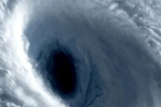
Scientists and Meteorologists are monitoring "INVEST 97" as further development of this tropical system is expected. We expect this tropical system to eventually strengthen into a Tropical Storm or a Hurricane.
Officials says to take measures now to protect your home, stock up on essential supplies. The Blake Moia Show recommends testing your generators and get them serviced now to ensure they are in working proper order. Remember to never run generators indoors.
Torrential monsoon downpours and flooding is widely expected throughout the state of Florida on Sunday and Monday, the forecasters say.
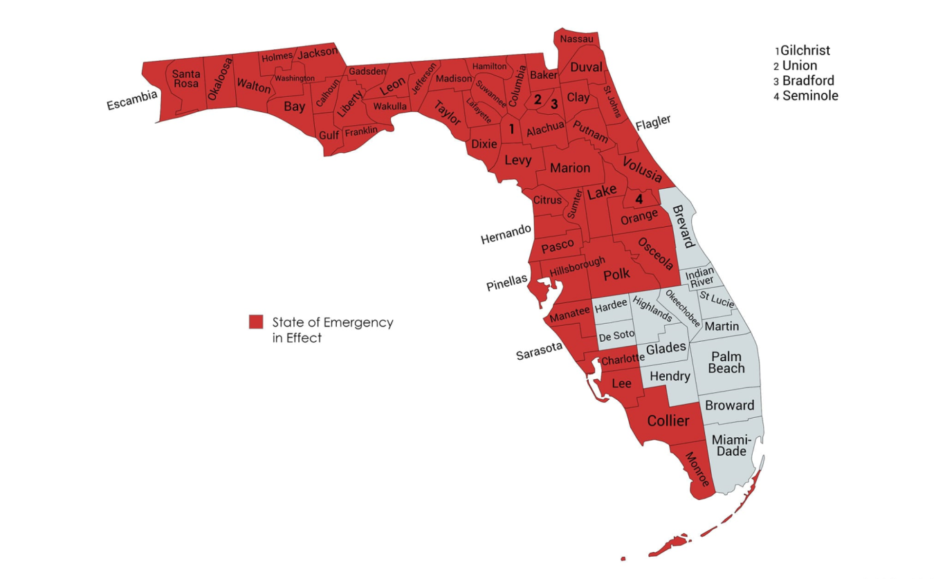
The Counties under a state of emergency: Alachua, Baker, Bay, Bradford, Calhoun, Charlotte, Citrus, Clay, Collier, Columbia, Dixie, Duval, Escambia, Flagler, Franklin, Gadsden, Gilchrist, Gulf, Hamilton, Hernando, Hillsborough, Holmes, Jackson, Jefferson, Lafayette, Lake, Lee, Leon, Levy, Liberty, Madison, Manatee, Marion, Monroe, Nassau, Okaloosa, Orange, Osceola, Pasco, Pinellas, Polk, Putnam, Santa Rosa, Sarasota, Seminole, St. Johns, Sumter, Suwannee, Taylor, Union, Volusia, Wakulla, Walton, and Washington.
000 AXNT20 KNHC 012335 TWDAT Tropical Weather Discussion
NWS National Hurricane Center Miami FL Issued by NWS National Hurricane Center Miami FL
0005 UTC Fri Aug 2, 2024
Tropical Weather Discussion for North America, Central America Gulf of Mexico, Caribbean Sea, northern sections of South America, and Atlantic Ocean to the African coast from the Equator to 31N. The following information is based on satellite imagery, weather observations, radar and meteorological analysis. Based on 1800 UTC surface analysis and satellite imagery through 2300 UTC.
...SPECIAL FEATURES... A robust tropical wave is analyzed with an axis along 72W from 12N to 23N, moving west around 15 kt. Scattered to numerous convection is occurring over a large area of disorganized showers and thunderstorms over Hispaniola, Puerto Rico, the Southeastern Bahamas, and the adjacent waters of the southwestern Atlantic and northeastern Caribbean Sea.
Development of this system should be slow to occur during the next day or so while it moves west-northwestward over portions of the Greater Antilles. However, environmental conditions are forecast to be more conducive for development after the wave passes the Greater Antilles, and a tropical depression is likely to form this weekend or early next week over the eastern Gulf of Mexico near the Florida Peninsula. This system has a medium chance of tropical cyclone formation through the next 48 hours, and a high chance of tropical cyclone formation through 7 days.
Please, see the latest NHC Tropical Weather Outlook at www.hurricanes.gov for more details. Gale Winds at the Canary Islands: A Gale Warning remains in effect for the Meteo-France marine zone Canarias. Gusty winds to gale force are expected between islands through 02/12Z. Please visit website: https://wwww.wwmiws.wmo.int
...TROPICAL WAVES... An eastern Atlantic tropical wave is analyzed with an axis along 36W from 04N to 17N, and moving west at 10 to 15 kt. Scattered moderate convection is depicted from 08N TO 13N between 35W and 43W. ...MONSOON TROUGH/ITCZ... A monsoon trough extends from 16N16W through 10N49W. The ITCZ continued northwestward from 10N49W to 09N60W. Scattered convection is noted from 08N to 13N between 36W and 43W. Aside from the convection associated with the tropical wave, no notable convection is associated with either the Monsoon Trough or the ITCZ.
...GULF OF MEXICO... Weak high pressure remains in place across the Gulf. A few showers and isolated thunderstorms are evident across the basin, with a cluster of scattered moderate to strong convection near the Bay of Campeche. Seas of 2 to 4 feet are noted, and fresh NE winds continue across southern portions of the basin For the forecast, a weak ridge will remain in place over the N Gulf waters into Sat morning allowing for gentle to moderate winds for most of the Gulf of Mexico. Fresh NE winds are expected near and to the northwest of the Yucatan Peninsula at night tonight and Fri night due to local effects. Looking ahead, a well-defined tropical wave will encounter favorable environmental conditions as it moves into the SE Gulf, and a tropical depression is likely to form this weekend or early next week over the eastern Gulf of Mexico near the Florida Peninsula.
...CARIBBEAN SEA... A well defined tropical wave is over Hispaniola. Please, see the Tropical Waves section for more details. Moisture associated with this wave is supporting moderate to locally strong convection over southern Cuba. Fresh E to SE winds are occurring near the wave axis, with highest winds noted near the convection. In addition to the convection associated with the tropical wave, showers and thunderstorms are also active over the southwest Caribbean, affecting near-shore portions of Costa Rica and Panama. Fresh to strong E winds and seas of 3 to 5 ft with the maximum seas occurring over central portions of the basin, north of Colombia.
For the forecast, a strong tropical wave moving westward will cross the central Caribbean through Fri and the W Caribbean through Sat night. While the wave will bring scattered showers and isolated thunderstorms, it will also break up the dominance of the Atlantic ridge over the basin and allow winds and seas to diminish some across the central and W Caribbean through Sun morning. Looking ahead, winds and seas will increase again across the central Caribbean by late Sun as high pressure builds in the wake of the tropical wave.
...ATLANTIC OCEAN... A well defined tropical wave is over Hispaniola, affecting the southeast Bahamas and the Turks and Caicos Islands. Please, see the Tropical Waves section for more details. The Bermuda-Azores High continues to dominate much of the Atlantic forecast waters, centered near 36N50W. A recent scatterometer satellite pass indicated fresh to strong NE winds near the Canary Island and southward to near 20N. Seas of 6 to 8 feet are common across this region. Otherwise, gentle to moderate winds and moderate seas persist across much of the waters.
Fresh to locally strong E to SE winds are occurring from Puerto Rico and the Dominican Republic north to 25N. Buoy observations showed seas of 5 to 8 ft in this area. For the forecast west of 55W, a well-defined tropical wave is producing a large area of disorganized showers and thunderstorms over Hispaniola, Puerto Rico, the Southeastern Bahamas, and the adjacent waters of the southwestern Atlantic and northeastern Caribbean Sea. Development of this system should be slow to occur during the next day or so while it moves west- northwestward over portions of the Greater Antilles. However, environmental conditions are forecast to be more conducive for development after the wave passes the Greater Antilles, and a tropical depression is likely to form this weekend or early next week over the eastern Gulf of Mexico. Elsewhere, the trades will remain moderate or weaker for the next several days. $$ ERA/ERA
Forecasters Monitoring Tropical Wave - Heavy Rains Expected for Florida
Tropical Weather Outlook NWS National Hurricane Center Miami FL 800 PM EDT Thu Aug 1 2024
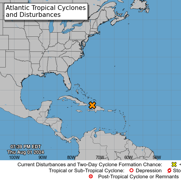
A well-defined tropical wave is producing a large area of disorganized showers and thunderstorms over Hispaniola, the southeastern Bahamas, and the adjacent waters of the southwestern Atlantic. The wave is expected to move west-northwestward near or over Cuba on Friday and then emerge over the Straits of Florida Friday night or Saturday.
Environmental conditions are expected to be conducive for additional development after that time, and a tropical depression is likely to form this weekend over the Straits of Florida or eastern Gulf of Mexico near the Florida Peninsula.
Regardless of development, heavy rains could cause areas of flash flooding across Florida, Cuba, and the Bahamas through the weekend, and interests in these locations should continue to monitor the progress of this system.
A NOAA Hurricane Hunter aircraft is scheduled to investigate this system on Friday, if necessary.
* Formation chance through 48 hours...medium...40 percent.
* Formation chance through 7 days...high...70 percent. $$ Forecaster Berg
No Price Gouging
Florida's attorney general activates price gouging hotline ahead of storm. A press release from Moody's office said, "price gouging laws are now in effect for the counties covered by the state of emergency: Alachua, Baker, Bay, Bradford, Calhoun, Charlotte, Citrus, Clay, Collier, Columbia, Dixie, Duval, Escambia, Flagler, Franklin, Gadsden, Gilchrist, Gulf, Hamilton, Hernando, Hillsborough, Holmes, Jackson, Jefferson, Lafayette, Lake, Lee, Leon, Levy, Liberty, Madison, Manatee, Marion, Monroe, Nassau, Okaloosa, Orange, Osceola, Pasco, Pinellas, Polk, Putnam, Santa Rosa, Sarasota, Seminole, St. Johns, Sumter, Suwannee, Taylor, Union, Volusia, Wakulla, Walton and Washington counties."
Anyone who suspects price gouging can report it to the Florida Attorney General’s Office by visiting MyFloridaLegal.com or calling 1(866) 9NO-SCAM.
Florida’s price gouging law applies to items and services essential to getting ready for, or recovering from, a storm within the areas of a declared state of emergency, the press release explained. That may include generators, food, gasoline, hotel rooms, ice, lumber and water.
"Violators of the price gouging statute are subject to civil penalties of $1,000 per violation and up to a total of $25,000 for multiple violations committed in a single 24-hour period," the release said.
“Invest 97L is expected to bring heavy rain and powerful winds to much of the state," Moody said in a statement. "To help Floridians prepare for this event, we are activating the price gouging hotline to accept reports of extreme price increases on essential commodities. As the system approaches, I’m urging Floridians to finalize their storm preparations, monitor weather reports and follow the guidance of local authorities.”