Weekend Forecast: Dangerous Heat in Store; A Hot Summer Ahead
May 16, 2025 -- 04:05pm By: Joe Cantoras // The Blake Moia Show Certified Chief Meteorologist
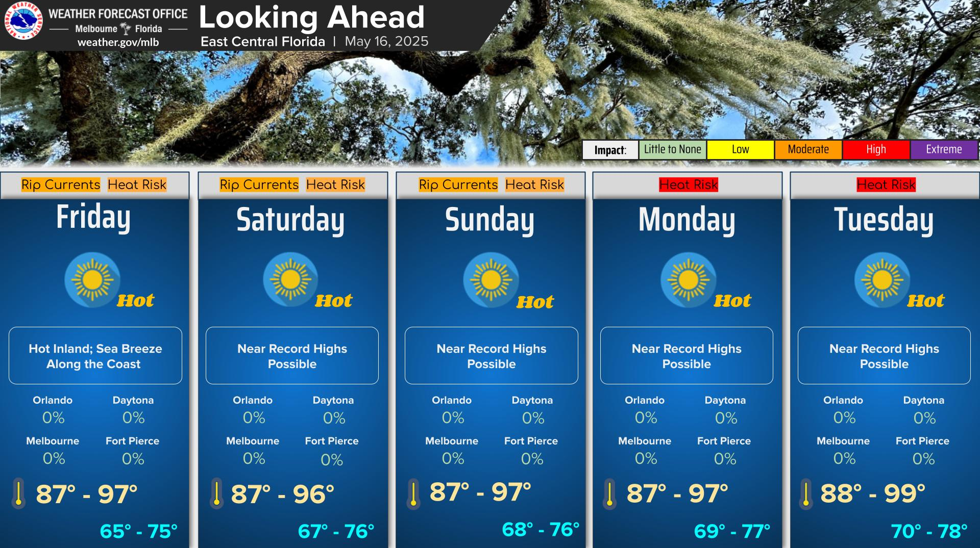
Above normal temperatures and dry conditions will continue into early next week, with near record temperatures forecast. The east coast sea breeze will form each afternoon, keeping the coast slightly cooler than the interior, but still remaining warm. Heat indices will be in the upper 90s to even low to mid 100s by early next week.
Drier than normal conditions are generally favored through the remainder of spring (through May), which is forecast to allow drought conditions to continue to persist or worsen across the area.
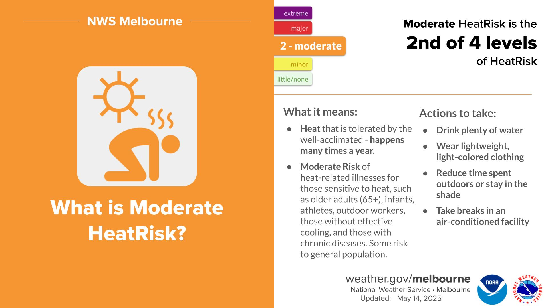
There is a moderate heat risk each afternoon with a major heat risk across portions of the Orlando metro on Monday. A moderate heat risk affects most people sensitive to heat, especially those without effective cooling and/or adequate hydration. A major heat risk affects anyone without effective cooling and/or adequate hydration.
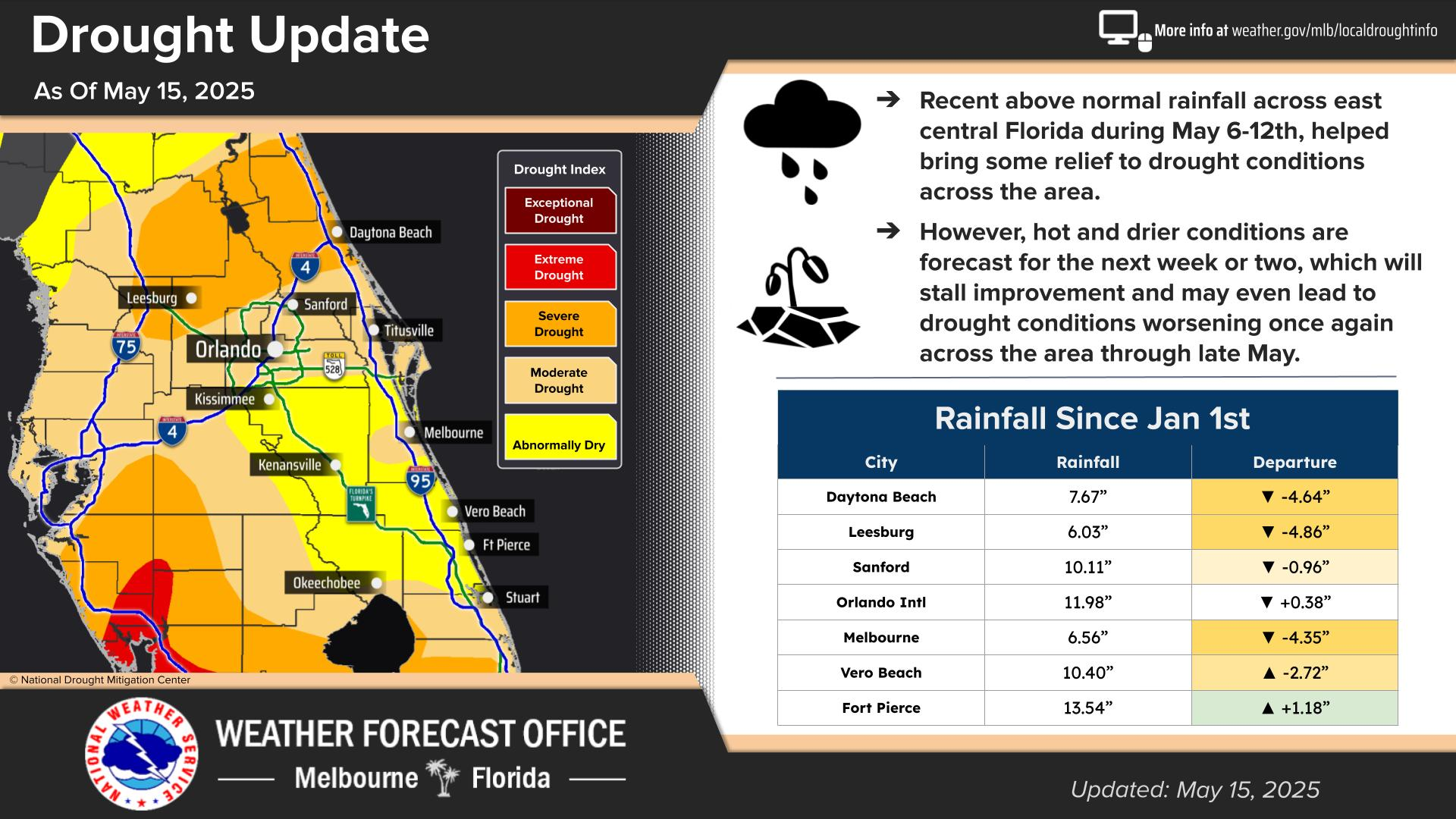
- Recent rainfall has brought some relief to the drought across east central FL. However, a hot and drier weather pattern forecast over the next week or two will stall improvement and may lead to drought conditions worsening once again through late May.
- Increasingly hot conditions forecast for East Central Florida this weekend and early next week with widespread low to mid 90s and near record high temperatures.
- Peak heat indices forecast to reach 100-105 this weekend into early next week.
- A Moderate to major heat risk will affect individuals sensitive to heat, especially those without effective cooling and/or adequate hydration.
- Very low rain chances (10% or less) through next Wednesday.
- Drought conditions may worsen/expand as a result.
Local radar imagery shows dry weather and GOES-16 satellite imagery shows mostly clear skies over east central Florida. High pressure (~1018mb) is situated over the eastern Gulf of America and the state of Florida.
Temperatures are currently in the mid 80s to low 90s with dew points in the upper 70s to mid 80s. Winds are from the west-southwest at around 5-10mph. Dry and hot conditions are forecast today with high pressure over Florida.
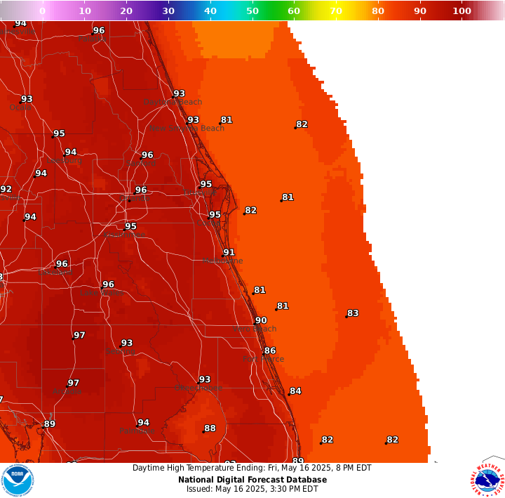
Above normal (~5-10F+) to near record highs are forecast this afternoon with ECMWF and NAEFS ensembles indicating temperatures at the 97.5th to maximum percentile for this time of year.
Afternoon highs in the upper 80s to mid 90s with heat index values in the mid 90s to 101F degrees are forecast under mostly sunny skies. There is a moderate to high heat risk for most of east central Florida.
- This level of heat affects most individuals sensitive to heat, especially those without adequate hydration.
It is recommended that those who spend extended periods of time outside this afternoon and early evening to drink plenty of water, wear light-colored clothing, reduce time spent outdoors or stay in the shade, and take breaks in an air conditioned facility.
A mid-level ridge (591-592dm) over the Gulf will nose NE across the FL peninsula and result in rising heights and increased subsidence.
In the low levels, Atlantic high pressure ridge axis will remain across south central FL, promoting a light offshore wind flow to start the day, turning onshore behind the sea breeze this afternoon.
Overall dry, subsident airmass will limit even fair weather cumulus from developing though there will be cirrus/cirrostratus streaming SE. These high clouds will be pretty thin so they should not affect max temps much. Widespread max temps in the mid 90s across interior sections as well as inland portions of the coastal counties.
Even coastal Volusia will reach the mid 90s before a delayed sea breeze develops. This will put Daytona Beach in a good position to equal (or even exceed) its record high of 94F (see below). Heat indices will also be on the climb with peak afternoon values in the upper 90s/near 100.
Saturday thru Wednesday...
The deep layer ridging will persist producing hot temperatures and rain chances no higher than 10 percent. Widespread mid 90s will continue over the interior with a few upper 90s possible with potential for one or more record highs to be equaled or even exceeded.
Coastal sections will hold in the lower 90s but there is a better chance for a more delayed sea breeze along the Volusia coast where the offshore flow is a bit stronger so Daytona Beach may again approach their record high on Sat (See below).
Peak heat indices are forecast to reach 100 to 105 each day inland from the coast. Widespread coverage of moderate heat risk are forecast with major heat risk impacts possible Orlando metro Sun-Tue.
It is worth noting heat risk takes into account the time of year, so while these temperatures and heat indices are not unusual for our summertime, they are well above normal for mid May and folks are not at all acclimated to it.
This level of heat affects most individuals sensitive to heat, especially those without effective cooling and/or adequate hydration.
Thursday...
A weak cool front is forecast to bring the next small chance (20-30%) for measurable rainfall on Thursday.
If timing becomes faster, may need to move these low rain chances to Wednesday but did not want to show 2 days of rain chances per NBM. Both GFS and ECMWF show a return to onshore flow late next week behind this front which would bring max temps down to more seasonable mid to upper 80s even if not much rainfall materializes.
Fire Danger Warning In Effect
FIRE WEATHER... Issued at 413 AM EDT Fri May 16 2025:
Soils will continue to dry out next several days with no rain in the forecast and temperatures reaching the low and mid 90s daily.
In addition, relatively dry air will produce min RH values of 30-35 percent over the interior today and Saturday but winds will be light (10 mph or less) so conditions will not reach Red Flag criteria.
Winds will turn onshore each afternoon behind the sea breeze, although its inland penetration will be slow and onset delayed especially north of the Cape. Min RH values close to the coast south of the Cape will hold near 50 percent.
MORE WEATHER: THE BLAKE MOIA SHOW 2025 HURRICANE PREDICTION CENTER
HIGH FIRE DANGER
High pressure at the surface and aloft will remain in control through the weekend into early next week, promoting hot and dry conditions. Wind speeds 10 mph or less will generally be out of the southwest to west but also variable at times given proximity to the ridge axis.
Winds will turn onshore each afternoon behind the sea breeze, although its inland penetration will be slow. Above normal temperatures will reach the low to mid 90s each day and combined with relatively low dewpoints, min RH values will reach 30-35 percent over interior sections today and around 35 percent Saturday.
But given the light winds, Red Flag conditions are not in the forecast. Min RH values close to the coast south of the Cape will hold near 50 percent. Deep mixing will help offset the light surface and transport winds and produce generally Good dispersion with Very Good dispersion across north interior sections.
- Fog potential and other remarks:
Patchy fog is possible early this morning mainly north and west of Interstate 4. Localized visibility reductions due to smoke from new or existing fires will be possible even if fog is not forecast.
- Marine:
Issued at 413 AM EDT Fri May 16 2025
High pressure ridge axis is forecast to remain nearly stationary across south central Florida, roughly across Lake Okeechobee and northernmost Bahamas, through the weekend and into early next week.
This pattern will produce largely favorable boating conditions with a light offshore (W-SW) flow each morning shifting E-SE increasing 10-14 knots near the coast behind the sea breeze each afternoon. Seas 1-2 FT nearshore and 3 FT offshore through Sat then 1-2 FT all waters Sun-Tue.
- AVIATION:
Issued at 104 PM EDT Fri May 16 2025
Continued mainly VFR. SW/WSW winds 5-10 kts across the interior will become light (5 kts or less) later this evening and overnight.
The ECSB will develop early this afternoon moving slowly inland, though it will be delayed along the Volusia coast with minimal inland movement (if any at all), backing winds E/SE and increasing to 10-14 kts. Light/variable morning winds on Saturday will transition W/SW and increasing to 5-10 kts during the day (interior).
The ECSB develops by early Sat afternoon with slow push inland and a likely delay along the Volusia coast, once again. Persistent overall pattern with conditions dry.


©Copyright 2024. All rights reserved. The Blake Moia Show. Privacy Policy
We need your consent to load the translations
We use a third-party service to translate the website content that may collect data about your activity. Please review the details in the privacy policy and accept the service to view the translations.