Tropical Storm Melissa Expected To Form Into Catastrophic Hurricane As Jamacia Prepares For Impacts
October 23, 2025 -- 00:30pm By: Joe Cantoras // TheBlakeMoiaShow.com Certified Chief Meteorologist & Tropical Weather Expert
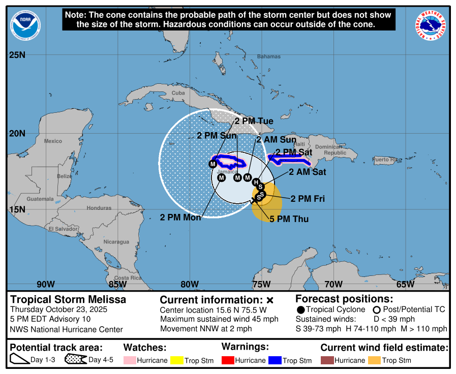
- 05pm tropical advisory for Tropical Storm Melissa
- Melissa forecasted to become Category 1 Hurricane over the weekend
- Tropical storm warnings issued for Jamacia and portions of Haiti
- Highly uncertain forecast model guidance on track
- Increased odds for tropical storm force winds impacting the Florida Keys and other portions of Southern Florida
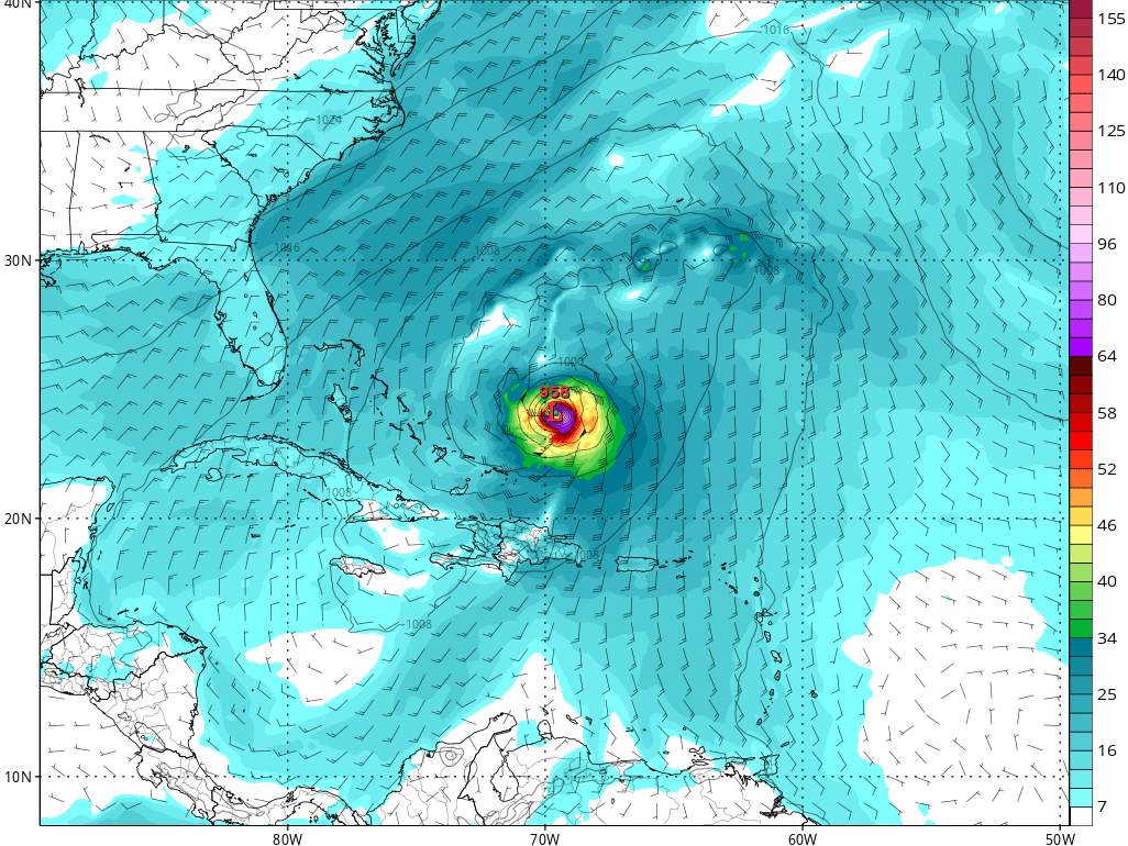
TBMS super-highres future forecast model showing a major hurricane being taken out to see by a trough about October 28, 2025
- BULLETIN
- Tropical Storm Melissa Advisory Number 10
- NWS National Hurricane Center Miami FL
- AL132025 500 PM EDT Thu Oct 23 2025
...MELISSA CONTINUES TO DRIFT NORTH-NORTHWESTWARD WITH LITTLE CHANGE IN INTENSITY... ...HEAVY RAINS AND LIFE-THREATENING FLOODING EXPECTED AND STRONG WINDS POSSIBLE FOR PORTIONS OF HISPANIOLA AND JAMAICA INTO THE WEEKEND...
SUMMARY OF 500 PM EDT...2100 UTC...
INFORMATION ----------------------------------------------
LOCATION...15.6N 75.5W ABOUT 185 MI...300 KM SSE OF KINGSTON JAMAICA ABOUT 295 MI...475 KM SW OF PORT AU PRINCE HAITI
MAXIMUM SUSTAINED WINDS...45 MPH...75 KM/H
PRESENT MOVEMENT...NNW OR 345 DEGREES AT 2 MPH...4 KM/H
MINIMUM CENTRAL PRESSURE...1001 MB...29.56 INCHES
WATCHES AND WARNINGS --------------------
CHANGES WITH THIS ADVISORY: None SUMMARY OF WATCHES AND WARNINGS IN EFFECT:
A Hurricane Watch is in effect for...
- * Southwestern peninsula of Haiti from the border with the Dominican Republic to Port-Au-Prince
- * Jamaica
A Tropical Storm Warning in effect for...
- * Southwestern peninsula of Haiti from the border with the Dominican Republic to Port-Au-Prince
- * Jamaica
A Hurricane Watch means that hurricane conditions are possible within the watch area.
A watch is typically issued 48 hours before the anticipated first occurrence of tropical-storm-force winds, conditions that make outside preparations difficult or dangerous.
A Tropical Storm Warning means that tropical storm conditions are expected somewhere within the warning area within 36 hours.
Interests elsewhere in Haiti, the Dominican Republic, and Cuba should monitor the progress of Melissa.
- A hurricane warning may be required for the island of Jamaica tonight or tomorrow. For storm information specific to your area, please monitor products issued by your national meteorological service.
DISCUSSION AND OUTLOOK ----------------------
At 500 PM EDT (2100 UTC), the center of Tropical Storm Melissa was located near latitude 15.6 North, longitude 75.5 West. Melissa is moving toward the north-northwest near 2 mph (4 km/h). A slow northward or north-northeastward motion is forecast during the next day or so, followed by a sharp turn westward over the weekend. On the forecast track, Melissa is expected to move closer to Jamaica and the southwestern portion of Haiti during the next couple of days. Maximum sustained winds are near 45 mph (75 km/h) with higher gusts. Gradual strengthening is forecast over the next day or so, followed by rapid intensification this weekend.
Melissa is forecast to become a hurricane by Saturday and a major hurricane by the end of the weekend. Tropical-storm-force winds extend outward up to 140 miles (220 km) from the center.
The estimated minimum central pressure is 1001 mb (29.56 inches).
HAZARDS AFFECTING LAND ----------------------
WIND:
- Hurricane conditions are possible within the watch area in Haiti and Jamaica beginning on late Friday or Saturday. Tropical storm conditions are expected to begin in Haiti and Jamaica earlier on Friday.
RAINFALL:
- Melissa is expected to bring 8 to 14 inches of rain to the southern Dominican Republic, southern Haiti, and eastern Jamaica through Sunday, with locally higher amounts possible. Additional heavy rainfall is likely beyond Sunday. However, uncertainty in Melissa’s track and forward speed reduces confidence in exact totals. Significant, life-threatening flash flooding and numerous landslides are expected. Across northern Dominican Republic, northern Haiti, and western Jamaica, 2 to 4 inches of rain is expected through Sunday. Flash and urban flooding will be possible through Sunday. Flooding impacts may increase across western Jamaica next week. For a complete depiction of forecast rainfall associated with Melissa, please see the National Weather Service Storm Total Rainfall Graphic, available at hurricanes.gov/graphics_at3.shtml?rainqpf
STORM SURGE:
- Minor coastal flooding is likely along the coast of Jamaica by late Friday into Saturday in areas of onshore winds as tropical storm conditions begin to reach the area. However, there is potential risk of a more significant storm surge, especially along the south coast of Jamaica, early next week. Due to Melissa’s slow motion and large forecast uncertainty, it is still too soon to know exactly how high the storm surge could reach. SURF: Swells generated by Melissa are expected to affect portions of Hispaniola, Jamaica, and eastern Cuba during the next several days. Please consult products from your local weather office.
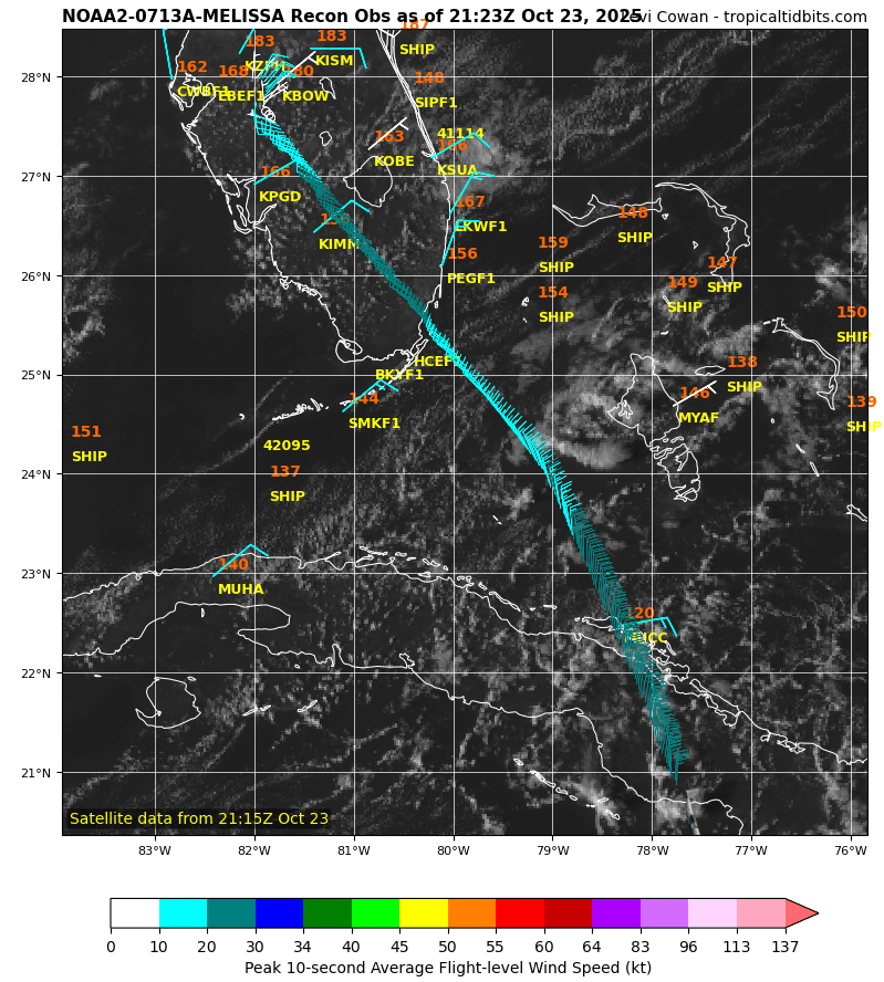
Current / latest aircraft recon data into Tropical Storm Melissa.
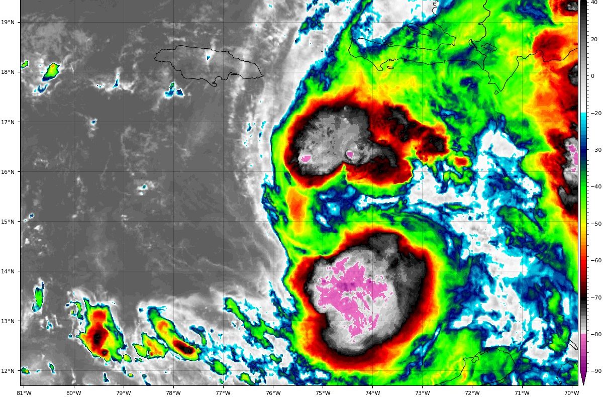
Latest Satellite Image Loop / Tropical Storm Melissa - Image Courtesy of Tropical Tidbits
- Tropical Storm Melissa Discussion Number 10
- NWS National Hurricane Center Miami FL
- AL132025 500 PM EDT Thu Oct 23 2025
Like the past couple of days, Melissa's structure has degraded once again this afternoon, with the low-level circulation yet again becoming partially exposed on the west side of the deepest convection. This structure is consistent with a tropical cyclone that continues to exhibit significant tilt with height in the downshear direction.
A scatterometer pass received after the prior advisory also indicated the center itself remains quite broad with a continued asymmetric wind field and large radius of maximum wind. The initial intensity is being held at 40 kt this advisory, without a substantial change in the subjective or objective intensity aids since the last recon plane left the storm.
A NOAA-P3 recon mission will sample the system this evening providing updated detail on the structure and intensity of the storm. Melissa continues to move very slowly, with the initial motion a very slow north-northwest drift at 345/2 kt. The tropical storm's very slow motion over the last day or so is related to it being caught between two mid-level ridges, one located to its southeast over the Lesser Antilles providing northeast steering, and another mid-level ridge building in northwest from Mexico providing southwest steering.
Their combined influence is roughly canceling Melissa's overall steering, with a lot of track influences the last couple of nights related to center reformations to the east and north. Interestingly, much of the hurricane-regional model guidance suggests another reformation could occur tonight, and the track guidance envelope has a distinct bend to the northeast in the 12 to 24 hour forecast points. Given the large convective burst ongoing just east of the current broad center, it is feasible it may nudge the short-term track east of due north.
After the next day or so, the mid-level ridge currently over Mexico is expected to expand poleward of the storm, and is expected to help turn Melissa to the west. How far north Melissa gets before it turns to the west continues to remain uncertain. One notable change from this morning is that the 12z Google DeepMind ensemble mean (GDMI), which was previously on the northeast side of the track guidance, abruptly shifted to the southwest side of the envelope, now very close to the latest 12z ECWMF forecast. In contrast, both the 12z HAFS-A/B regional hurricane models shifted their tracks further north and east, related to an overnight center reformation.
All these shuffling guidance tracks highlight the uncertainty of the overall track forecast, and the latest NHC track was only nudged slightly southward from this morning, blending the reliable HCCA and GDMI aids. This forecast track takes Melissa just south of Jamaica in 60-96 hours, though it is worth noting there are guidance aids that move it near or over Jamaica earlier in the forecast than shown here. Melissa's broad and asymmetric structure argues against much short-term intensification, though the shear that had been plaguing the system is soon expected to decrease.
It will likely take at least 24 hours for the storm's tilted structure to become better aligned to take advantage of the other favorable environmental factors (very warm sea-surface temperatures, sufficently moist mid-levels). Regardless, the intensity guidance is insistent on Melissa undergoing a period of rapid intensification in the forecast period, and all 50 members of the Google DeepMind ensemble show the system becoming a major hurricane or stronger.
The NHC intensity forecast will follow suit, showing rapid intensification from 36 to 72 h, intensifying Melissa from a tropical storm to a category 4 hurricane in this time period. Remarkably, this is still lower than some of the hurricane-regional models, and is in best agreement with the GDMI intensity forecast, which have plenty of members stronger this the current NHC peak intensity of 125 kt. Over the forecast period, the tropical cyclone is expected to grow in size significantly, and it will likely be a large and dangerous hurricane towards the end of the forecast period.
Key Messages:
1. Jamaica: Due to Melissa’s slow motion, the risk of a prolonged multi-day period of potentially damaging winds, heavy rainfall resulting in life-threatening flash flooding and numerous landslides, and storm surge continues to increase for Jamaica. Preparations to protect life and property should be rushed to completion, since strong winds and flooding rains could begin in Jamaica by Friday or Saturday.
2. Haiti: Heavy rainfall will result in catastrophic flash flooding and landslides across southwestern Haiti by this weekend into early next week. Extensive damage to roads and buildings is expected, potentially isolating communities for an extended period of time. This is a life-threatening situation and immediate preparations to protect life and property should be taken. Strong winds could also potentially last for a day or more over the Tiburon peninsula of Haiti.
3. Remainder of Hispaniola and Eastern Cuba: Heavy rainfall could also produce significant, life-threatening flash flooding and numerous landslides in southern Dominican Republic. Interests in Cuba should monitor the progress of Melissa since the risk of heavy rainfall, damaging winds, and storm surge appears to be increasing.
MORE WEATHER: THE BLAKE MOIA SHOW 2025 HURRICANE PREDICTION CENTER