End of September Forecast and Updated Tropical Outlook
September 17, 2025 -- 11:59pm By: Joe Cantoras // TheBlakeMoiaShow.com Certified Chief Meteorologist & Tropical Weather Expert
Central Florida -- Melbourne -- Palm Bay - Brevard County & Surrounding Areas --
A coverage of rain and lightning storms will gradually increase from south to north through late week; locally heavy rainfall possible across the Treasure Coast Thursday.
Temperatures remain near to slightly below normal this week and into early next week, especially across the south, where higher coverage of clouds and rain are forecast.
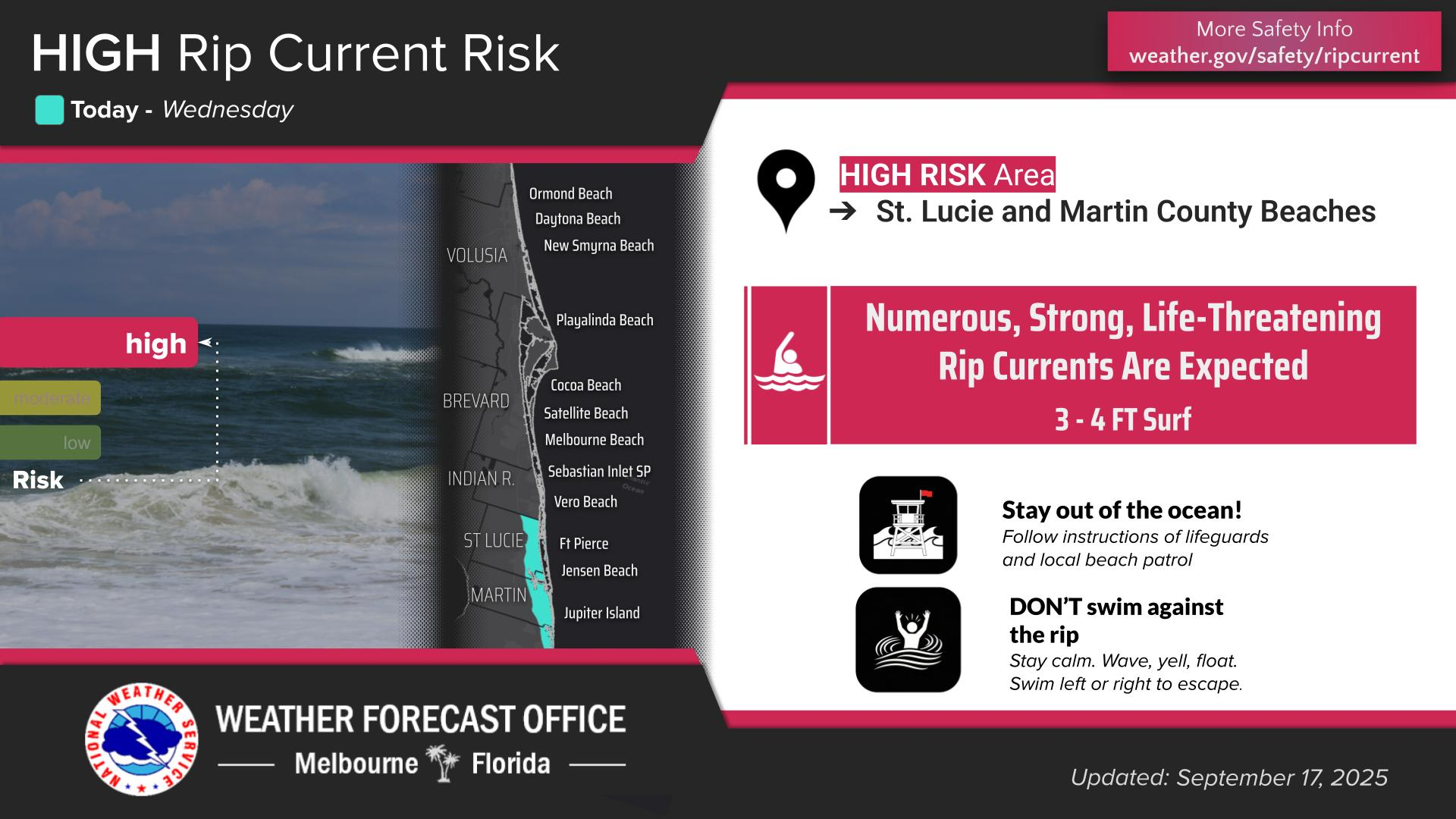
A high risk of rip currents exists at St. Lucie and Martin county beaches today, with a moderate risk at Volusia, Brevard, and Indian River county beaches.
- Slightly below normal temperatures into the weekend.
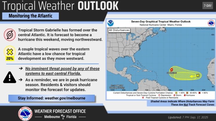
- Tropical systems being monitored, but poses no threats to Florida or USA.
- La Nina starting to kick in, which will produce warmer & drier conditions during Winter.
- Overall rain chances 50%.
Current-
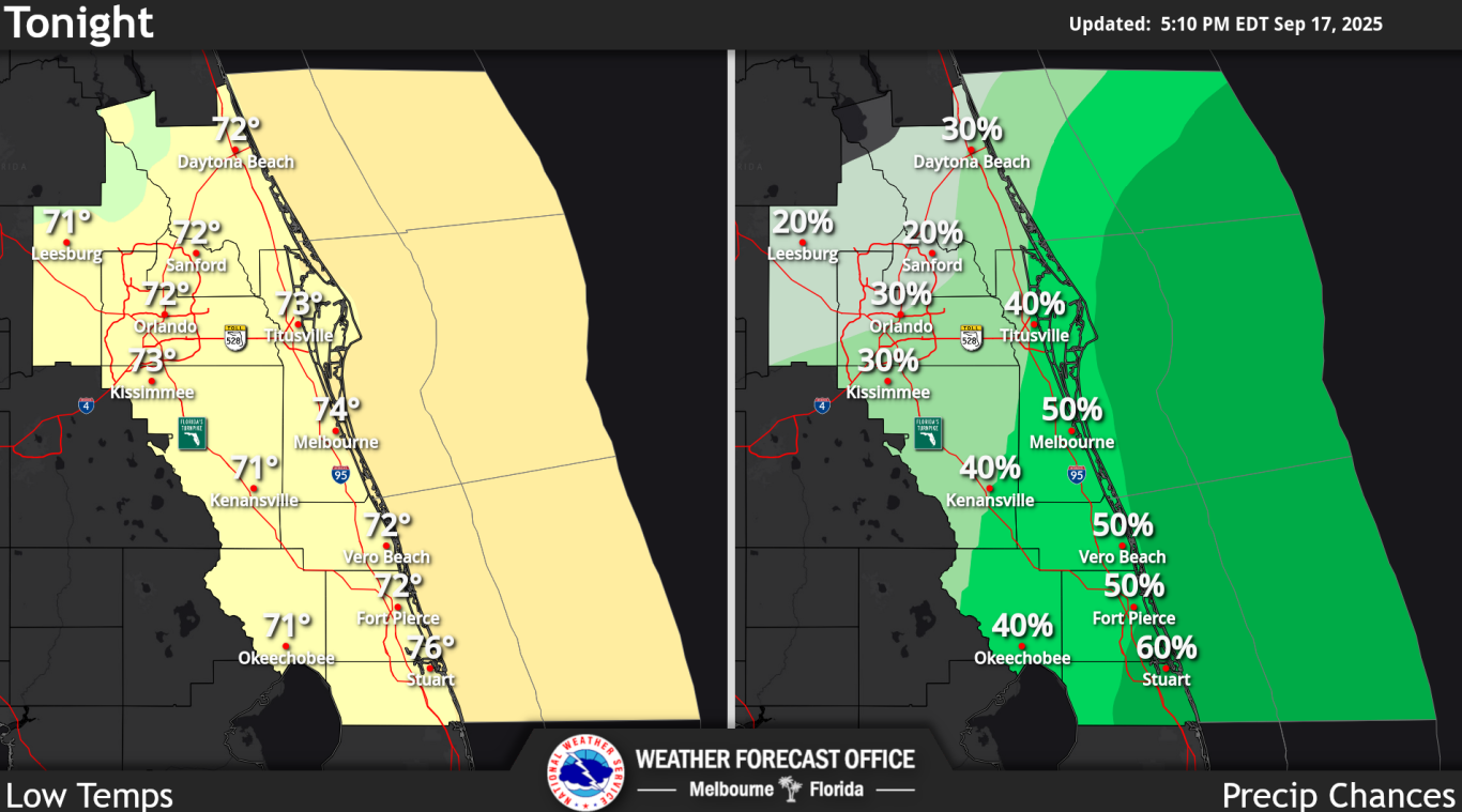
Tonight: Scattered showers have developed across portions of east central Florida this afternoon, primarily focused across the greater Orlando area. Lower cloud coverage across the north allowing for efficient daytime heating paired with increasing moisture has helped these showers easily develop. Activity farther south has been struggling as a result of a persistent cloud shield across the area, which has limited daytime heating and therefore, available energy.
However, CAM guidance continues to indicate development across the Treasure Coast and near Lake Okeechobee late afternoon into the evening hours as well as increasing coverage of showers across the northern portions of the forecast area.
While a lack of instability may be an inhibiting factor for storm development, shear, dry air aloft, and increasing PWATs will still support the potential for storm development this afternoon into the evening hours. Any storms that do manage to develop may be capable of producing lightning strikes, gusty winds to 45 mph, and heavy downpours.
Minor localized flooding in areas that see training or multiple rounds of showers and storms cannot be ruled out, and a Marginal Risk of excessive rainfall continues to be highlighted across portions of the Treasure Coast.
Activity from this afternoon is forecast to slowly diminish into the overnight hours across east central Florida, with ongoing development anticipated across the local Atlantic waters.
Persistent east to northeast flow may help some activity move onshore, with isolated showers and even a storm or two possible along the immediate coast overnight. Cloud cover is forecast to remain high as a result of the increasing moisture locally, with temperatures overnight falling into the upper 60s to low 70s.
Wednesday thru Thursday: A persistent middle to upper level trough across the eastern US will slowly shift eastward across the Atlantic on Thursday, with a brief period of quasi-zonal flow aloft forecast across the Florida peninsula Friday into the early weekend.
This flow will be short-lived as another trough begins to build towards the area as a mid to upper level trough gradually works its way eastward across Canada and towards the Great Lakes. A mid to upper level cutoff low then develops across the central US, resulting in a return of some mid-level ridging across the Florida peninsula towards the middle of next week.
At the surface, this pattern will allow for the reestablishment of a surface boundary that will meander near to just south of the forecast area late this week into early next week, resulting in increasing moisture locally.
By the middle of next week, the boundary is anticipated to diminish, with lingering moisture remaining across the area. This increasing moisture will result in greater rain chances across east central Florida through this weekend (30 to 70 percent). The greatest rain chances are focused across southern portions of the forecast area, where PWATs are anticipated to be highest (1.8 to 2.0").
Locally heavy rainfall will be a concern through the period, and there is a Marginal Risk for excessive rainfall for portions of the Treasure Coast on Thursday. Weak steering flow aloft combined with the higher moisture may support training activity and/or multiple rounds of slow-moving showers.
By next week, discrepancies in moisture between global models lead to some varying PoPs, so stuck with the NBM at 30 to 50 percent Monday through Wednesday.
Storm development cannot be ruled out with daily activity across east central Florida, with lightning strikes and gusty winds the main concerns aside from heavy rainfall and flooding. Activity is forecast to diminish late each evening across the peninsula, with ongoing development through the overnight hours possible across the local Atlantic waters.
Outside of showers and storms, east to northeast flow is forecast to persist through at least this weekend and into early next week, generally between 10 to 15 mph during the day and becoming lighter into the overnight hours. Temperatures are anticipated to remain near to slightly below normal in the mid 80s to low 90s through early next week, with lows in the low to mid 70s.
- MARINE... Issued at 300 PM EDT Wed Sep 17 2025
Increasing moisture across the local waters will lead to high rain chances (50 to 70 percent) through the end of this week and into the weekend. Storms cannot be ruled out with this activity, and any that manage to develop may be capable of producing lightning strikes, gusty winds in excess of 34 knots, locally heavy downpours that reduce visibilities, and locally higher seas.
Onshore flow around 10 knots will be enhanced each afternoon as the east coast sea breeze develops and moves across the peninsula, with winds reaching 10 to 15 knots. Seas of 2 to 4 feet are forecast to persist through the end of the work week, with building seas anticipated to reach up to 5 feet across the offshore waters this weekend.
- AVIATION... (00Z TAFs) Issued at 719 PM EDT Wed Sep 17 2025
Cloud cover persists through the period, remaining VFR outside of convection. Shield of Cirrostratus overhead has kept heating down and thus convective coverage lower (especially south of KMLB) this past afternoon/evening. Still TEMPO MVFR in the vicinity of scattered showers/ISOLD lightning storms favoring the interior this evening, but cannot rule out coastal convection overnight for those TAF sites.
Using "Vicinity" wording and TEMPO groups as necessary. ESE/SE winds becoming light this evening/overnight becoming NE/ENE on Thu and increasing to 6-12 kts. Convective evolution on Thu a bit "cloudy", while deepest moisture exists KMLB southward - cloud cover may again affect development/coverage.
TROPICAL WEATHER OUTLOOK
- Tropical Weather Outlook NWS National Hurricane Center Miami FL 800 PM EDT Wed Sep 17 2025 For the North Atlantic.
- Caribbean Sea and the Gulf of America - Active Systems:
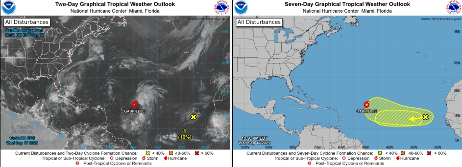
The National Hurricane Center is issuing advisories on Tropical Storm Gabrielle, located in the central Tropical Atlantic.
- East-Central Tropical Atlantic:
A tropical wave located near the Cabo Verde Islands continues producing disorganized showers and thunderstorms. Environmental conditions are only marginally conducive, and any development of this system should be slow to occur while it moves westward at 15 to 20 mph across the eastern and central portion of the tropical Atlantic.
Regardless of development, this system will continue to bring areas of heavy rain across the Cabo Verde Islands through Thursday.
* Formation chance through 48 hours...low...10 percent. * Formation chance through 7 days...low...10 percent.
- Eastern Tropical Atlantic:
A tropical wave is forecast to move off the coast of west Africa by Friday morning. Some slow development of this system is possible as it moves west-northwestward across the eastern tropical Atlantic this weekend into early next week.
* Formation chance through 48 hours...low...near 0 percent. * Formation chance through 7 days...low...20 percent.
Public Advisories on Tropical Storm Gabrielle are issued under WMO header WTNT32 KNHC and under AWIPS header MIATCPAT2. Forecast/Advisories on Tropical Storm Gabrielle are issued under WMO header WTNT22 KNHC and under AWIPS header MIATCMAT2.
MORE WEATHER: THE BLAKE MOIA SHOW 2025 HURRICANE PREDICTION CENTER
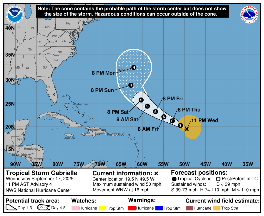
TROPICAL STORM GABRIELLE
- INFORMATION ---
LOCATION...19.4N 48.0W ABOUT 990 MI...1595 KM E OF THE NORTHERN LEEWARD ISLANDS
MAXIMUM SUSTAINED WINDS...50 MPH...85 KM/H
PRESENT MOVEMENT...NW OR 310 DEGREES AT 14 MPH...22 KM/H
MINIMUM CENTRAL PRESSURE...1005 MB...29.68 INCHES
- WATCHES AND WARNINGS ---
There are no coastal watches or warnings in effect.
- DISCUSSION AND OUTLOOK ---
At 500 PM AST (2100 UTC), the center of Tropical Storm Gabrielle was located near latitude 19.4 North, longitude 48.0 West.
Gabrielle is moving toward the northwest near 14 mph (22 km/h), and a northwest or west-northwest motion is expected to continue over the next few days. Satellite data indicate that the maximum sustained winds have increased to near 50 mph (85 km/h) with higher gusts.
Little change in strength is forecast during the next 48 hours, but some gradual intensification is forecast over the weekend. Tropical-storm-force winds extend outward up to 205 miles (335 km) from the center, primarily in the eastern semicircle of the storm.
The estimated minimum central pressure is 1005 mb (29.68 inches).
- HAZARDS AFFECTING LAND ----
NONE.