Tropical Storm Humberto Develops; Expected to Become Hurricane, Or Major Hurricane, As Another Tropical System Near Florida Is Forming
September 24, 2025 -- 05:15pm By: Joe Cantoras // TheBlakeMoiaShow.com Certified Chief Meteorologist & Tropical Weather Expert
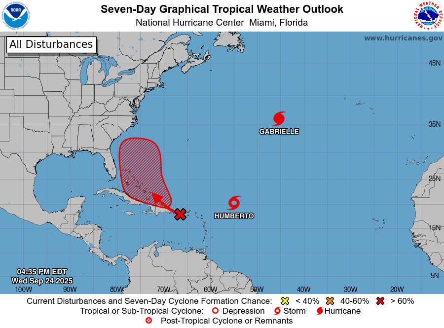
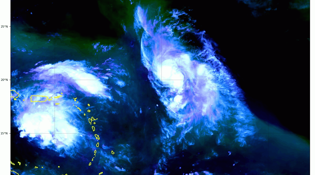
- Eastern Caribbean Sea (AL94):
Showers and thunderstorms have increased but remain disorganized in association with a tropical wave over the northeastern Caribbean Sea.
This wave is expected to move west-northwestward around 10 to 15 mph, spreading heavy rainfall and gusty winds into Puerto Rico and the Virgin Islands today, and across the Dominican Republic beginning tonight.
The system is then expected to slow down and turn northwestward when it reaches the southwestern Atlantic late this week. Environmental conditions are forecast to be more conducive for development in a few days, and a tropical depression is likely to form when the disturbance is in the vicinity of the Bahamas.
Interests in the Virgin Islands, Puerto Rico, the Dominican Republic, the Turks and Caicos Islands, and the Bahamas should monitor the progress of this system. An Air Force Hurricane Hunter Aircraft is en-route to perform a system survey to gather data from the surrounding environment, according to the National Hurricane Center.
* Formation chance through 48 hours...low...30 percent.
* Formation chance through 7 days...high...80 percent.

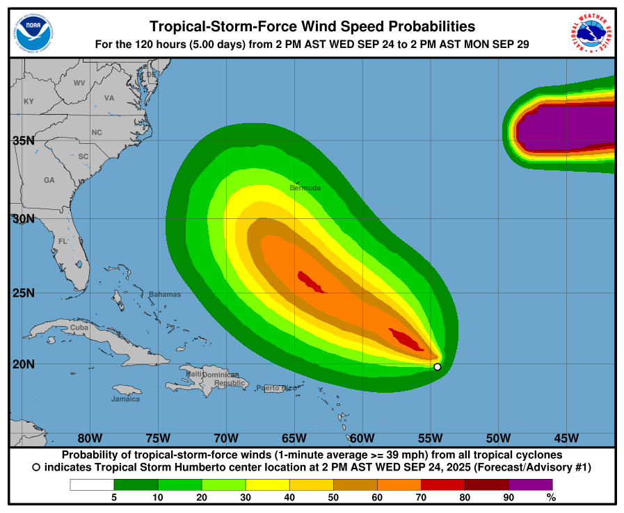
Tropical Storm Humberto Wind Predictions & Percentages of Probabilities Map - NHC
- Tropical Storm Humberto Discussion Number 1
- NWS National Hurricane Center Miami FL AL082025 500 PM AST
- Wed Sep 24, 2025
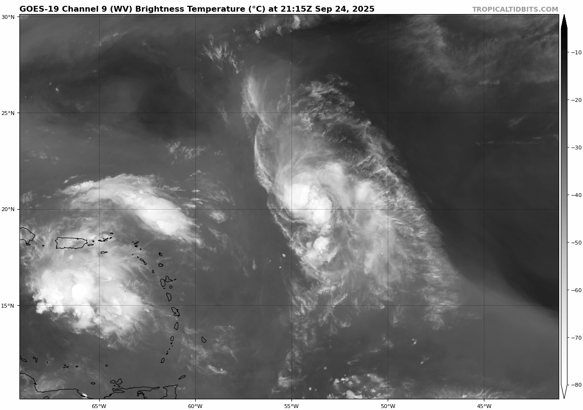
Satellite data indicates that Invest 93L over the central tropical Atlantic has now developed into Tropical Storm Humberto.
Visible satellite imagery shows that throughout the day, the low-level center has become well-defined, with persistent and organized deep convection mainly located over the eastern side of the system.
- Subjective Dvorak intensity estimates from TAFB and SAB were both data-T/2.5 35 kt.
- DPRINT and DMINT Objective Intensity estimates from UW-CIMSS range from 31 to 35 kt.
Using these data, the initial intensity is set to 35 kt. The system is estimated to be moving west-northwestward at 300/13 kt, but this is of low confidence since the center has only recently formed.
A west-northwestward to northwestward motion is anticipated through the next several days along the southwestern periphery of a mid-latitude ridge. Towards the end of the forecast period, an approaching trough moving offshore the east coast of the United States will erode the ridge and allow the system to turn more northward.
However, there is quite a bit of uncertainty with the forward speed and cross-track spread of the system. This is increasingly apparent beyond day 3 as there are complex steering components with timing differences in the global models, including the approaching trough and potential binary interaction with Invest 94L.
The NHC track forecast lies near the consensus aids given some of these uncertainties, and there is lower than normal confidence in the track forecast.
The storm is within a favorable environment for strengthening with warm sea surface temperatures near 29C and moist mid-level RH values. The system will be dealing with some moderate westerly wind shear for the next day or so that will likely cause an asymmetric storm structure.
EC and GFS SHIPS guidance depict the shear slightly weakening in the day 2 to 4 time frame, and with increasing divergence aloft, a slightly greater rate of strengthening is shown at that time.
The latest NHC forecast follows these trends and lies near the consensus intensity aids.
Tropical Storm Humberto Forecast Discussion
- SUMMARY OF 500 PM AST...2100 UTC...INFORMATION ----------------------------------------------
- LOCATION...20.1N 54.9W ABOUT 550 MI...885 KM ENE OF THE NORTHERN LEEWARD ISLANDS
- MAXIMUM SUSTAINED WINDS...40 MPH...65 KM/H
- PRESENT MOVEMENT...WNW OR 300 DEGREES AT 15 MPH...24 KM/H
- MINIMUM CENTRAL PRESSURE...1008 MB...29.77 INCHES
- WATCHES AND WARNINGS:
There are no coastal watches or warnings in effect.
- DISCUSSION AND OUTLOOK ----------------------
At 500 PM AST (2100 UTC), the center of Tropical Storm Humberto was located near latitude 20.1 North, longitude 54.9 West. Humberto is moving toward the west-northwest near 15 mph (24 km/h).
A west-northwest to northwest motion is expected over the next several days with a slower forward speed. Maximum sustained winds are near 40 mph (65 km/h) with higher gusts.
Steady strengthening is forecast during the next several days. Tropical-storm-force winds extend outward up to 45 miles (75 km) from the center. The estimated minimum central pressure is 1008 mb (29.77 inches).
- HAZARDS AFFECTING LAND ----------------------
None
- NEXT ADVISORY -------------
Next complete advisory at 1100 PM AST.
MORE WEATHER: THE BLAKE MOIA SHOW 2025 HURRICANE PREDICTION CENTER
HURRICANE GABRIELLE TO EFFECT THE AZORES
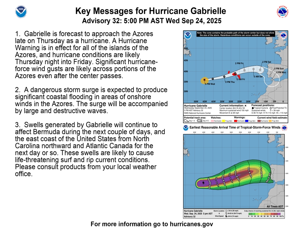
- ...GABRIELLE FORECAST TO BRING HURRICANE CONDITIONS TO THE AZORES LATE THURSDAY OR EARLY FRIDAY...
- SUMMARY OF 800 PM AST...0000 UTC...
- INFORMATION ----------------------------------------------
- LOCATION...36.1N 43.5W ABOUT 915 MI...1475 KM W OF THE AZORES
- MAXIMUM SUSTAINED WINDS...100 MPH...155 KM/H
- PRESENT MOVEMENT...E OR 80 DEGREES AT 29 MPH...46 KM/H
- MINIMUM CENTRAL PRESSURE...970 MB...28.65 INCHES
- WATCHES AND WARNINGS --------------------
- SUMMARY OF WATCHES AND WARNINGS IN EFFECT:
- A Hurricane Warning is in effect for... * All of the Azores *
A Hurricane Warning means that hurricane conditions are expected somewhere within the warning area. A warning is typically issued 36 hours before the anticipated first occurrence of tropical-storm- force winds, conditions that make outside preparations difficult or dangerous.
Preparations to protect life and property should be rushed to completion. For storm information specific to your area, please monitor products issued by your national meteorological service.
- DISCUSSION AND OUTLOOK ----------------------
At 800 PM AST (0000 UTC), the center of Hurricane Gabrielle was located near latitude 36.1 North, longitude 43.5 West. Gabrielle is moving toward the east near 29 mph (46 km/h). An eastward to east-northeastward motion is expected during the next couple of days, followed by a slower eastward to east-southeastward motion this weekend.
On the forecast track, the center of Gabrielle will approach the Azores during the day on Thursday and move across the island chain late Thursday into early Friday. Maximum sustained winds are near 100 mph (155 km/h) with higher gusts. Some weakening is forecast during the next few days, but Gabrielle is forecast to be at hurricane strength when it passes through the Azores.
Hurricane-force winds extend outward up to 45 miles (75 km) from the center and tropical-storm-force winds extend outward up to 160 miles (260 km). The estimated minimum central pressure is 970 mb (28.65 inches).
- HAZARDS AFFECTING LAND ----------------------
Key messages for Gabrielle can be found in the Tropical Cyclone Discussion under AWIPS header MIATCDAT2 and WMO header WTNT42 KNHC.
- WIND:
Hurricane conditions are expected in the Azores Thursday night into early Friday, with tropical storm conditions likely by Thursday evening. Significant hurricane-force wind gusts are likely across portions of the Azores even after the center passes.
- STORM SURGE:
A dangerous storm surge is expected to produce significant coastal flooding in areas of onshore winds in the Azores. The surge will be accompanied by large and destructive waves.
- RAINFALL:
From Thursday into Friday morning, Gabrielle may bring 3 to 5 inches, or 75 to 125 mm, of rainfall across the central and western Azores. During the same time, outer bands from Gabrielle may also result in 1 to 2 inches, or 25 to 50 mm, of rain across the eastern Azores.
- SURF:
Swells generated by Gabrielle will continue to affect Bermuda over the next couple of days, and the U.S. East Coast from North Carolina northward and Atlantic Canada over the next day or so. Swells from Gabrielle will begin reaching the Azores on Thursday. These swells are expected to produce life-threatening surf and rip current conditions. Please consult products issued by your local weather office.